 CNR-ISMAR
model
Type of resources
Topics
INSPIRE themes
Keywords
Contact for the resource
Provided by
Years
Formats
Representation types
Update frequencies
status
-
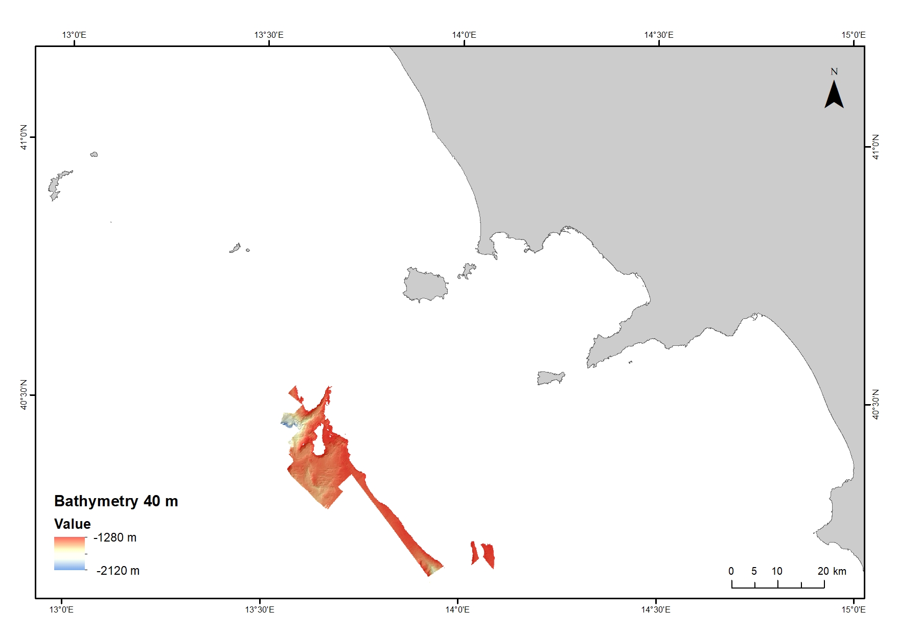
Digital Elevation Model (DEM) from 1280 to 2120 water depth at 40 meters resolution. Bathymetric surface collected during the oceanographic cruise JAMMEGAIA22 on board of the R/V GAIA BLU by CNR.
-
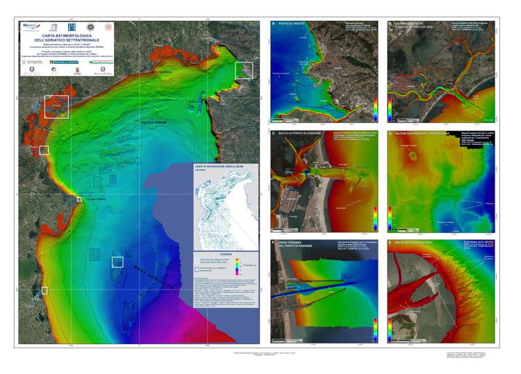
La carta batimorfologica dell’Adriatico Settentrionale che include anche le lagune di Venezia e di Grado e Marano ed è il risultato di una collaborazione tecnico-scientifica tra vari Enti, tra cui il CNR e l’IIM (Istituto Idrografico Militare). La carta è composta da un corpo principale che illustra il modello di elevazione dei fondali marini (risoluzione di 200m) derivato dall’integrazione di tutti i dati acquisiti con ecoscandagli a fascio singolo (single-beam) con una esagerazione verticale di 30x, necessaria ad evidenziare le principali caratteristiche geomorfologiche della piattaforma Nord Adriatica. La carta batimetrica include una serie di poligoni blu (key map) che illustrano la copertura dei dati a maggiore risoluzione raccolti con ecoscandaglio multifascio (Multibeam) acquisiti dal CNR ISMAR, IGAG e dall’IIM, sia lungo costa che in mare aperto, dal 2005 ad oggi. Il rilievo Multibeam della laguna di Venezia, include le tre bocche di porto di Venezia, Chioggia e Malamocco (Madricardo et.al, 2017) è stato integrato al dato Singlebeam, visibile nel corpo carta principale. A destra del corpo carta sono state realizzate sei carte batimetriche ad alta risoluzione che evidenziano i rilievi Multibeam condotti nel porto di Ravenna, alla foce del Fiume Po (Po di Pila) nelle Lagune di Venezia (Laguna Nord e bocca di porto di Chioggia), nel porto di Trieste, nell’area off-shore Ravenna (depositi di sabbie relitte attribuite a depositi trasgressivi). La cartografia è visibile attraverso il WebGIS o scaricabile direttamente al link indicato di seguito.
-
nessuno
-
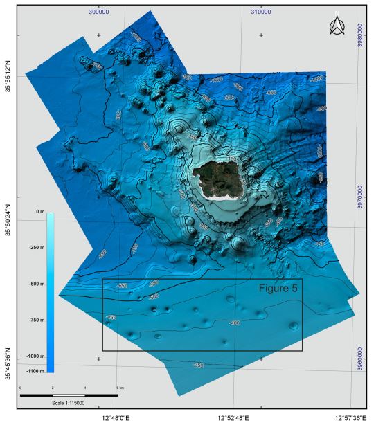
Bathymetry of Linosa Island (10 × 10 m cell grid size) collected by the Institute for Coastal Marine Environment (IAMC, now ISMAR, Institute of Marine Sciences) of the National Research Council (CNR) of Naples (Italy) during two oceanographic surveys, ‘Linosa 2016’ (17–29 August 2016) and ‘BioGeoLin 2017’ (8–20 September 2017), onboard the R/V Minerva UNO
-
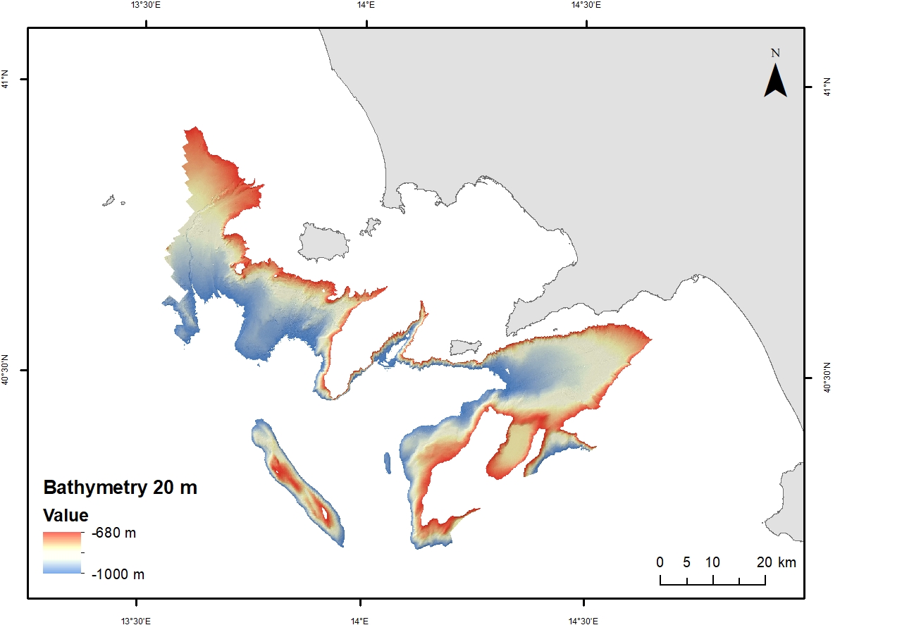
Digital Elevation Model (DEM) from 680 to 1000 m water depth with a spatial resolution of 20 m. Bathymetric surface collected during the oceanographic cruise JAMME GAIA 2022 on board of the R/V GAIA BLU by CNR.
-

Spatial and vertical extension of the mesophotic zone in the Mediterranean Sea based upon light penetration
-
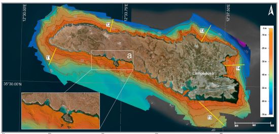
High-resolution DTM with 2.5 m grid cell size produced from the bathymetric survey carried out aboard the M/B ‘Risal’ in April 2015, in order to map the whole margin of Lampedusa Island, in the 2–50 m depth range.
-
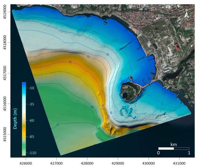
Bathymetric dataset collected in the frame of the research project ABBaCO (Environmental Restoration of the Bagnoli-Coroglio National Site of Interest). The Project was aimed to support planning actions for the restoration of marine habitats of the Bagnoli-Coroglio area, characterized by the presence of a large industrial site from 1910 until the 1990s. Bathymetric data were collected by means of a Teledyne Reson SeaBat 7125 multibeam echosounder and processed using PDS 4.1 (Teledyne©inc) editing software.
-

Digital Elevation Model (DEM) of the Ave estuary in Portugal collected by Deltares in the framework of the MAELSTROM Project
-
Bathymetric surface acquired in the framework of the TREMOR24 oceanographic campaign (CORSUB Project)