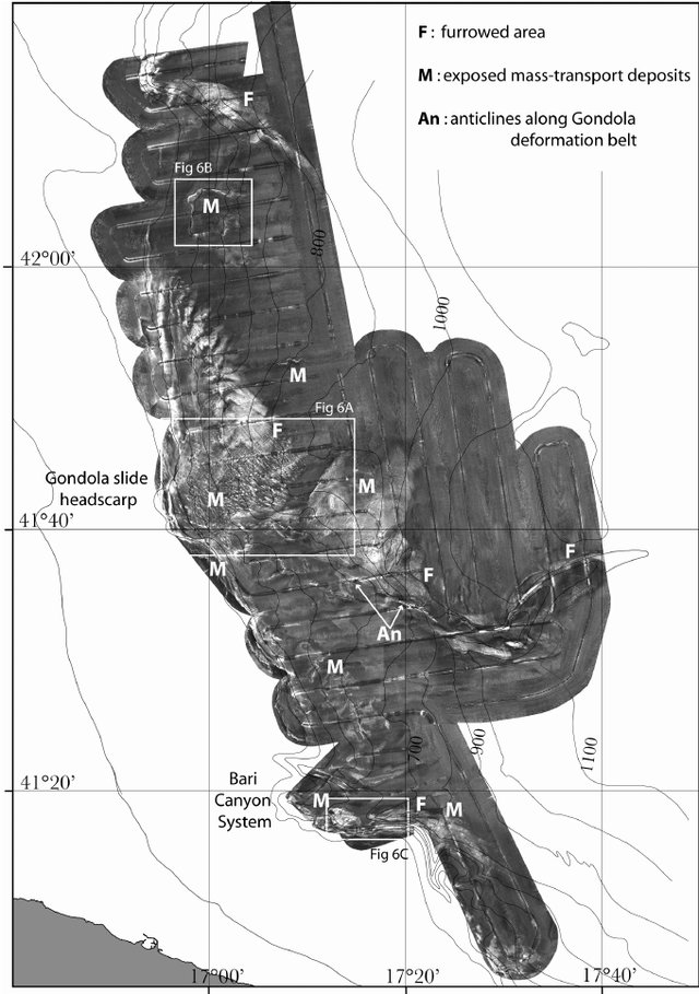
TOBI side-scan-sonar mosaic
A 30-kHz TOBI side-scan-sonar mosaic offers information about the seafloor back-scatter and macro morphology, side-scan-sonar data were collected during the oceanographic cruise SAGA-03 in the framework of the European project EUROSTRATAFORM (EC contract no. EVK3-CT-2002-00079) and processed at the “National Oceanographic Center, Southampton” following the methods defined by Le Bas et al. (1995)
Simple
- Date (Creation)
- 2021-04-29
- Identifier
- http://libeccio.bo.ismar.cnr.it:8080/geonetwork/srv/ita/catalog.search#/metadata/c6970d73-2192-48ce-b273-85f24cb859fb / GEONETWORK
- Unique resource identifier
- none
- Credit
- © CNR-ISMAR
- Status
- On going
Principal investigator
National Research Council (CNR)
-
Fabio Trincardi
(
Researcher
)
Bologna
,
Italy
https://orcid.org/0000-0002-8476-8804
- Maintenance and update frequency
- As needed
- GEMET - INSPIRE themes, version 1.0
-
- Reflectivity
- Geology
- Marine regions and subregions
-
- Adriatic Sea
- Platform Type
-
- research vessel
- Survey type
-
- Geophysics
- Cartography
- Survey
-
- SAGA-03
- Collection method
-
- Sonar system
- Device
-
- Multibeam
- Swath type
-
- Seabed reflectivity
- Use limitation
- None
- Use constraints
- License
- Other constraints
- CC-BY
- Access constraints
- Other restrictions
- Other constraints
- By negotiation
- Classification
- Restricted
- Spatial representation type
- Grid
- Metadata language
- Italiano
- Character set
- UTF8
Extent
- Description
- mediterranean sea; eastern basin; adriatic sea

Extent
- Begin date
- 2012-12-29
- End date
- 2013-01-09
- Supplemental Information
- Minisini, D., Trincardi, F., and Asioli, A.: Evidence of slope instability in the Southwestern Adriatic Margin, Nat. Hazards Earth Syst. Sci., 6, 1–20, https://doi.org/10.5194/nhess-6-1-2006, 2006
- Reference system identifier
- EPSG:3857 - WGS84 Web Mercator (Auxiliary Sphere)
- Topology level
- Geometry only
- Geometric object type
- Surface
- Geometric object count
- 1
- Number of dimensions
- 3
- Dimension name
- Column
- Dimension size
- 3585
- Resolution
- 18 meter
- Dimension name
- Row
- Dimension size
- 3940
- Resolution
- 18 meter
- Cell geometry
- Area
- Transformation parameter availability
- No
- Distribution format
-
-
Shapefile
(
.shp
)
-
GEOTIFF
(
.tif
)
- Specification
- NAS ISMAR Bologna
-
Shapefile
(
.shp
)
Distributor
National Research Council (CNR) - Institute of Marine Science (ISMAR)
http://www.ismar.cnr.it/
- OnLine resource
-
Seafloor reflectivity SAGA03
(
WWW:DOWNLOAD-1.0-http--download
)
Mosaic (ascii, shapefile)
- Hierarchy level
- Dataset
- Dataset
- Seafloor reflectivity
Conformance result
- Date (Publication)
- 2020-10-09
- Explanation
- Validated in Geonetwork according to the ISO19115 rules (25/25) and the INSPIRE rules (30/30)
- Pass
- Yes
- Statement
- Minisini, D., Trincardi, F., and Asioli, A.: Evidence of slope instability in the Southwestern Adriatic Margin, Nat. Hazards Earth Syst. Sci., 6, 1–20, https://doi.org/10.5194/nhess-6-1-2006, 2006
- Description
- Processed by CNR-ISMAR with the software CARIS v. xx
- File identifier
- c6970d73-2192-48ce-b273-85f24cb859fb XML
- Metadata language
- English
- Character set
- UTF8
- Parent identifier
- Survey SAGA-03 7af5101a-e7a5-4e42-a202-c9e559a8c35e
- Hierarchy level
- Dataset
- Hierarchy level name
- Seafloor reflectivity
- Date stamp
- 2023-07-02T00:53:05
- Metadata standard name
- ISO 19115:2003/19139
- Metadata standard version
- 1.0
 CNR-ISMAR

