CNR-ISMAR
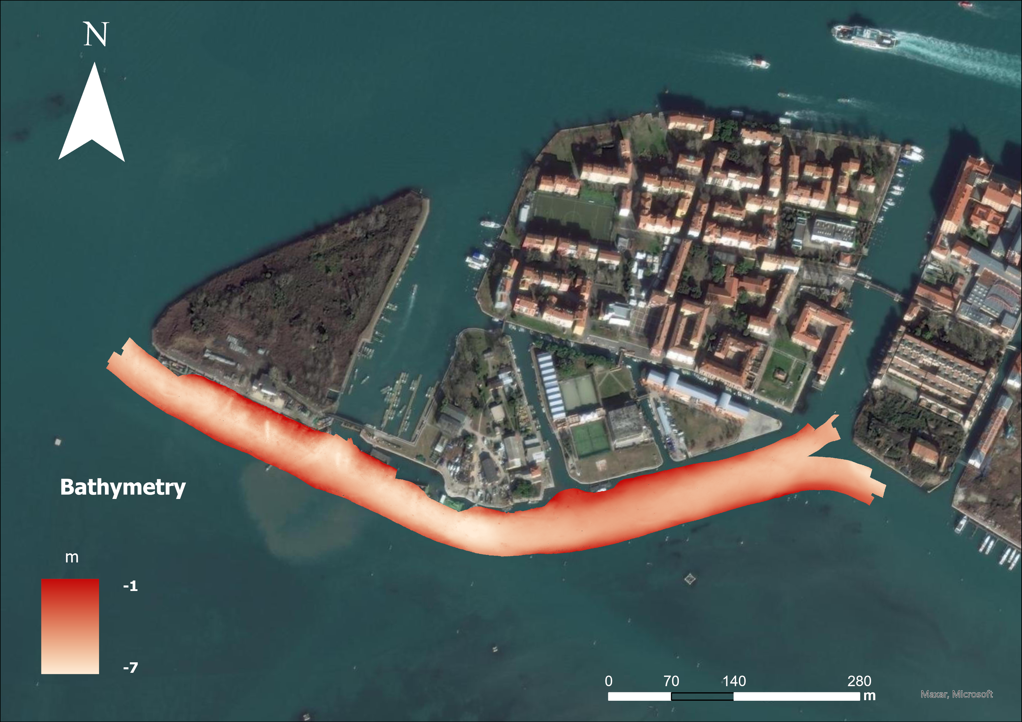
MAELSTROM: Sacca Fisola 2022 November Bathymetry
Base
- Data (Creazione)
- 2023-02-09
- Identificatore
- http://libeccio.bo.ismar.cnr.it:8080/geonetwork/srv/eng/catalog.search#/metadata/c1dff77c-6c59-46c8-8f5e-025155da31e9 / GEONETWORK
- Identificatore
- none
- Crediti
- © MAELSTROM - Smart technology for MArinE Litter SusTainable RemOval and Management funded by the European Union, Programme H2020-EU.3.2.5.1. Grant agreement No 101000832. https://doi.org/10.3030/101000832
- Status
- In corso
- Frequenza di aggiornamento
- Secondo necessità
- Collection method
-
- Sonar system
- Device
-
- Multibeam
- Swath type
-
- Bathymetry
- Project
-
- MAELSTROM
- Parole chiave
-
- Venice lagoon
- GEMET - INSPIRE themes, version 1.0
-
- Elevation
- Continents, countries, sea regions of the world.
-
- Mediterranean Sea
- Adriatic Sea
- Limitazione d’uso
-
MAELSTROM data policy: https://zenodo.org/records/15030538
MAELSTROM data access request form: https://zenodo.org/records/15030591
- Vincoli di accesso
- Altri vincoli
- Altri vincoli
- Available on request
Vincoli sulla risorsa
- Vincoli di fruibilità
- Licenza
- Altri vincoli
- Creative Commons Attribution 4.0 International
- Classificazione
- Non riservato
- Tipo di rappresentazione spaziale
- Dati vettoriali
- Lingua dei metadati
- Italiano
- Set dei caratteri dei metadati
- UTF8
- Tema
-
- Quote e prodotti derivati
Estensione
- Descrizione
- mediterranean sea; eastern basin; adriatic sea

Estensione
- Data di inizio
- 2012-12-29
- Data di fine
- 2013-01-09
- Informazioni supplementari
- none
- Identificatore del sistema di riferimento
- WGS_1984_UTM_Zone_33N
- Livello di topologia
- Solo Geometria
- Oggetto di tipo geometrico
- Superficie
- Conteggio oggetto geometrico
- 1
- Formato di distribuzione
-
-
Shapefile
(
.shp
)
-
GEOTIFF
(
.tif
)
- Specifiche
- NAS ISMAR Bologna
-
Shapefile
(
.shp
)
- Risorsa online
-
Automatic detection of MLs targets from the bathymetry
(
WWW:LINK-1.0-http--link
)
Research Object in ROHub
- Risorsa online
-
Sacca Fisola 2022 November Bathymetry
(
WWW:LINK-1.0-http--link
)
Sacca Fisola 2022 November Bathymetry ( MAELSTROM Project)
- Livello
- Modello
- Dataset
- Bathymetric surface
Conformità
- Data (Pubblicazione)
- 2020-10-09
- Spiegazione
- Validated in Geonetwork according to the ISO19115 rules (25/25) and the INSPIRE rules (30/30)
- Pass
- Yes
- Genealogia del dato – Processo di produzione
-
The data were collected in May 2022 by CNR- ISMAR VE within the MAELSTROM project with the aim to map marine litter on the seafloor. A Kongsberg EM-2040p compact single head multi-frequency multibeam system (MBES), 512 beams per swath, 1° beamwidth at 400 KHz, was used, selecting an operational frequency of 320 KHz.
The Multibeam was pole-mounted on the CNR research vessel Litus, a 11-m-long boat with 1.5-m-deep draft. The acquisition system is furnished with a Seapath 380 system, supplied by Real Time Kinematic (RTK) online corrections and integrated with the Kongsberg motion sensor MRU 5 and with a Dual Antenna GPS, that allow to take in account for ship positioning and for pitch, roll, heave and yaw movements. The system was completed by a Valeport mini SVS sensor to continuously measure the sound velocity for the beamforming and by a Sound velocity profiles (SVPs).
The collected data were processed by CNR- ISMAR VE with the Caris HIPS & SIPS 11 software following the standard procedures for data conversion, tide correction (tide data provided by ISPRA, referred to the ZMPS 1897), creation of surfaces, cleaning of spurious data and application of refraction coefficients for the correction of speed of sound errors.
- Identificatore del file di metadati
- c1dff77c-6c59-46c8-8f5e-025155da31e9 XML
- Lingua dei metadati
- English
- Set dei caratteri dei metadati
- UTF8
- Livello gerarchico
- Modello
- Data dei metadati
- 2025-03-15T09:54:26
- Nome dello Standard dei metadati
- ISO 19115:2003/19139
- Versione dello Standard dei metadati
- 1.0