CNR-ISMAR
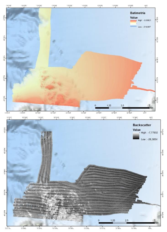
FEAMP ISSPA - Procida bathymetry & backscatter
Nell’ambito del progetto FEAMP ISSPA (Linea 1.4 e Linea 2.51) è stato effettuato un rilievo Multi Beam allo scopo di indagare i fondali relativi alle aree identificate come potenzialmente idonee all’acquacultura. Tali rilievi hanno lo scopo di completare la mappa degli habitat bentonici e delle caratteristiche
fisiche del substrato necessario alla corretta pianificazione spaziale marittima e all’identificazione delle pressioni multiple all’interno dell’area marina protetta Regno di Nettuno e del Sito Natura 2000 Fondali marini di Ischia Procida e Vivara. Il rilievo è stato effettuato con Multi Beam Knosgber 2040 C e Seapath 130-J. Sono state effettuate sonde per il profilo di velocità dell’acqua circa 2 volte al giorno con Mini SVP Valeport. È stata effettuata la calibrazione dello strumento all’inizio del rilievo e sono stati corretti i parametri di pitch, yaw a roll. L’elaborazione preliminare dei dati è stata effettuata a bordo con il software CARIS HIPS and SIPS ed è stato prodotto un DTM e un mosaico della riflettività a 1 m di risoluzione per tutta l’area indagata. Le mappe sono state estituite con il software ArcGIS 10.8.
Simple
- Date (Creation)
- 2022-08-09
- Identifier
- http://libeccio.bo.ismar.cnr.it:8080/geonetwork/srv/eng/catalog.search#/metadata/b8cd2eaf-9e4a-4ecc-aaf8-8b835e4e0707 / GEONETWORK
- Unique resource identifier
- none
- Credit
- © FEAMP ISSPA
- Status
- Completed
- Maintenance and update frequency
- As needed
- GEMET - INSPIRE themes, version 1.0
-
- Elevation
- Habitats and biotopes
- Agricultural and aquaculture facilities
- Survey type
-
- Geophysics
- Cartography
- Collection method
-
- Sonar system
- Device
-
- Multibeam
- Swath type
-
- Bathymetry
- Campaign
-
- FEAMP Procida
- Project
-
- FEAMP ISSPA
- Continents, countries, sea regions of the world.
-
- Mediterranean Region
- Tyrrhenian Sea
- Italy
- Use limitation
- None
- Use constraints
- Other restrictions
- Other constraints
- FEAMP ISSPA data policy
- Access constraints
- Other restrictions
- Other constraints
- By negotiation
- Classification
- Restricted
- Spatial representation type
- Vector
- Metadata language
- English
- Character set
- UTF8
- Topic category
-
- Elevation
Extent
- Description
- mediterranean sea

Extent
- Begin date
- 2021-06-19
- End date
- 2021-06-23
- Supplemental Information
- none
- Reference system identifier
- EPSG:3857 - WGS84 Web Mercator (Auxiliary Sphere)
- Topology level
- Geometry only
- Geometric object type
- Surface
- Geometric object count
- 1
- Distribution format
-
-
Shapefile
(
.shp
)
-
ESRI GRID
(
.asc
)
- Specification
- NAS ISMAR Bologna
-
Shapefile
(
.shp
)
- Hierarchy level
- Dataset
- Dataset
- Bathymetric surface
Conformance result
- Date (Publication)
- 2020-10-09
- Explanation
- Validated in Geonetwork according to the ISO19115 rules (25/25) and the INSPIRE rules (30/30)
- Pass
- Yes
- Statement
- Il rilievo è stato effettuato con Multi Beam Knosgber 2040 C e Seapath 130-J. Sono state effettuate sonde per il profilo di velocità dell’acqua circa 2 volte al giorno con Mini SVP Valeport. È stata effettuata la calibrazione dello strumento all’inizio del rilievo e sono stati corretti i parametri di pitch, yaw a roll. L’elaborazione preliminare dei dati è stata effettuata a bordo con il software CARIS HIPS and SIPS ed è stato prodotto un DTM e un mosaico della riflettività a 1 m di risoluzione per tutta l’area indagata. Le mappe sono state restituite con il software ArcGIS 10.8.
- Description
- Processed by CNR-ISMAR with the software CARIS HIPS and SIPS
- Date / Time
- 2021-06-23T00:00:00
- File identifier
- b8cd2eaf-9e4a-4ecc-aaf8-8b835e4e0707 XML
- Metadata language
- English
- Character set
- UTF8
- Parent identifier
- Survey FEAMP Procida 3172bdf6-b980-4593-9568-a1235f00ae62
- Hierarchy level
- Dataset
- Date stamp
- 2023-10-20T12:51:17
- Metadata standard name
- ISO 19115:2003/19139
- Metadata standard version
- 1.0