 CNR-ISMAR
145_DTM_CNR-ISMAR-22_Adriatic_singlebeam
Base
- Titolo alternativo
- DTM_CNR-ISMAR-22
- Data (Creazione)
- 2006-06-10T12:00:00
- Data (Revisione)
- 2008-10-25T12:00:00
- Identificatore
- DTM_CNR-ISMAR-22
- Thèmes Sextant
-
- /Physical Environment/Bathymetry/Digital Terrain Model
- Project name
-
- EMODNet Seabed Mapping
- SeaDataNet device categories
-
- single-beam echosounders
- SeaDataNet device categories
-
- Differential Global Positioning System receivers
- Parameter Discovery Vocabulary (P02)
-
- Bathymetry and Elevation
- GEMET - INSPIRE themes, version 1.0
-
- Hydrography
- Vincoli di accesso
- Dato a conoscibilità limitata
- Vincoli di fruibilità
- Proprietà intellettuale dei dati
- Altri vincoli
-
Intellectual property : CNR-ISMAR Bologna
Obligation of citation : Fabio Trincardi, Elisabetta Campiani, Annamaria Correggiari, Federica Foglini, Vittorio Maselli & Alessandro Remia (2014) Bathymetry of the Adriatic Sea: The legacy of the last eustatic cycle and the impact of modern sediment dispersal, Journal of Maps, 10:1, 151-158, DOI: 10.1080/17445647.2013.864844
- Limitazione d’uso
- The Single Beam bathymetry of the Italian side of the Adriatic compiled by ISMAR can be applied in oceanographic numerical model as uniform resolution GRID. The main advantages in using this kind of bathymetry, obtained from manual interpretation and contouring, is the generation of consistent model taking into account the actual sea floor morphology and its relation to key geological features. The main limitation come from the heterogeneity of the bathymetric data in terms of distribution and quality, and the possible errors generated during the interpolation procedures applied to derive an homogeneous resolution GRID. Not for navigation
- Tipo di rappresentazione spaziale
- Dati raster
- Denominatore
- 50000
- Distanza
- 200 Metres (m)
- Lingua dei metadati
- English
- Set dei caratteri dei metadati
- UTF8
- Tema
-
- Acque marine
- Data di inizio
- 1991-05-18T12:00:00
- Data di fine
- 2005-03-17T12:00:00
))
- identificatore Geografico
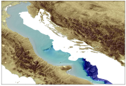
- Adriatic Sea (Mediterranean Sea)
- identificatore Geografico
- EPSG / WGS84 / UTM33 / 7.4
- Identificatore del sistema di riferimento
- EPSG / WGS 84 (EPSG:4326) / 7.4
- Numero delle dimensioni
- 3
- Nome dimensione
- Colonna
- Misura dimensione
- 4123
- Nome dimensione
- Riga
- Misura dimensione
- 4741
- Nome dimensione
- Tempo
- Misura dimensione
- 1
- Geometria della cella
- Punto
- Disponibilità dei coefficienti della trasformazione
- No
- Disponibilità dei checkpoint
- No
- Punto del pixel
-
- In basso a sinistra
- Formato di distribuzione
-
-
ArcGIS Ad_tot_sb.asc, Ad_tot_sb.xyz
(
Not specified
)
-
ArcGIS Ad_tot_sb.asc, Ad_tot_sb.xyz
(
Not specified
)
- Dimensioni di trasferimento
- 60
- Risorsa online
-
ISMAR FTP
(
WWW:LINK
)
Downloading after registration. Contact ISMAR in Bologna (http://www.ismar.cnr.it/) :
- Risorsa online
-
Scientific paper
(
WWW:LINK-1.0-http--link
)
Fabio Trincardi, Elisabetta Campiani, Annamaria Correggiari, Federica Foglini, Vittorio Maselli & Alessandro Remia (2014) Bathymetry of the Adriatic Sea: The legacy of the last eustatic cycle and the impact of modern sediment dispersal, Journal of Maps, 10:1, 151-158, DOI: 10.1080/17445647.2013.864844
- Livello
- Dataset
Estensione verticale
- Quota minima
- 114
- Quota massima
- 1204
gml:verticalCS
gml:verticalDatum
- Genealogia del dato – Processo di produzione
- no information
- Livello
- Feature
- Dataset
- accuracy
Accuratezza posizionale di dati griglia
- Nome di misura
- horizontal accuracy
- Misura di identificazione
- horizontal accuracy of coordinate
- Descrizione dell misura
- Variable quality depending on time of data collection. High accuracy given by a manual interpretation and contouring before gridding.
Misure di qualità dei dati
- Tipo di valore
- horizontal accuracy
Accuratezza di attributo quantitativo
- Nome di misura
- depth
- Misura di identificazione
- depth accuracy
- Descrizione del metodo di valutazione
- CTD calibration especially in areas with variable sound speed profiles.
Misure di qualità dei dati
- Valore
- not defined
Conformità
- Data
- Pass
- No
- Livello
- Software
- Descrizione
- PANGEA Multi Beam Manager
- Altro
- software
- Livello
- Tipo di proprietà
- Descrizione
- parameters of data processing
- Genealogia del dato – Processo di produzione
-
Description of data processing :
The bathymetric data were migrated in a GIS Database and plotted as water depth points on different maps, at different scale depending on the soundings density, dividing the Adriatic in subset areas from north to south. Following an interpretative approach, based also on the interpretation of geological sub-seafloor features using CHIRP-sonar profiles, the bathymetric contours were manually drawn and digitised as vector data in a GIS, with variable space according to water depth range (contour every 1 m from 5 to 150 m and every 20 m from 150 m to 1200 m). The contours were used to generate a uniform GRID (200 m) using a kriging algorithm with variable resolution depending on the soundings density.
- Descrizione
-
Description of processed data sources :
Single Beam sonar data were collected using an hull-mounted Echo sounder (Atlas Deso25 operating at frequencies of 12, 100, 33 and 210KHz) along about 17.830 km of seismic profiles during 22 cruises performed by ISMAR from 1991 to 2005 on board R/V Urania in the Italian side of the Adriatic Sea. The echo sounding profiles are unevenly distributed and the seafloor coverage is within the range of one sounding every 20-40 m, along track. The Echo sounder Atlas Deso25 was merged with the navigation system NAV PRO from Communication Technology and with DGPS positioning system with metrical accuracy.
CDIs list of single beam echosounder surveys using single beam echosounder (18) used to produce the DTM :
145_CNR-ISMAR-23,145_CNR-ISMAR-24, 145_CNR-ISMAR-25, 145_CNR-ISMAR-26, 145_CNR-ISMAR-27, 145_CNR-ISMAR-28, 145_CNR-ISMAR-29, 145_CNR-ISMAR-30, 145_CNR-ISMAR-31, 145_CNR-ISMAR-32, 145_CNR-ISMAR-33, 145_CNR-ISMAR-34, 145_CNR-ISMAR-35, 145_CNR-ISMAR-36, 145_CNR-ISMAR-37, 145_CNR-ISMAR-38, 145_CNR-ISMAR-39, 145_CNR-ISMAR-40.
- Livello
- Dataset
Accuratezza posizionale dei dati
- Nome di misura
- emodnet-bathymetry.QI.Horizontal
- Valore
- 3 - < 20 m
Accuratezza posizionale dei dati
- Nome di misura
- emodnet-bathymetry.QI.Vertical
- Valore
- 1 - SBES low frequency, SDB (similar than 2+5%d)
Consistenza di dominio
- Nome di misura
- emodnet-bathymetry.QI.Purpose
- Valore
- 2 - Bathymetric/morphologic survey
- Identificatore del file di metadati
- SDN_CPRD_145_DTM_CNR-ISMAR-22 XML
- Lingua dei metadati
- English
- Set dei caratteri dei metadati
- UTF8
- Nome del livello gerarchico
- Composite Product Record
- Data dei metadati
- 2024-02-07T16:24:01
- Nome dello Standard dei metadati
- ISO 19115:2003/19139 - EMODNET - BATHYMETRY
- Versione dello Standard dei metadati
- 1.0