 CNR-ISMAR
VENICE LAGOON CHANNELS DTM 5 m
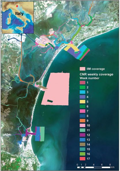
The multibeam data were collected during six-months in 2013 with a Kongsberg EM2040 compact dual-head multi-frequency system. Metadata for the 17-week-long survey is available from the Seadatanet catalogue CDIs: 145_CNR-ISMAR-102,145_CNR-ISMAR-103,145_CNR-ISMAR-104,145_CNR-ISMAR-105,145_CNR-ISMAR-106,145_CNR-ISMAR-107,145_CNR-ISMAR-108,145_CNR-ISMAR-109,145_CNR-ISMAR-110,145_CNR-ISMAR-111,145_CNR-ISMAR-112,145_CNR-ISMAR-113,145_CNR-ISMAR-114,145_CNR-ISMAR-115,145_CNR-ISMAR-116,145_CNR-ISMAR-117,145_CNR-ISMAR-118.
Base
- Data (Creazione)
- 2017-07-03T00:00:00
- Data (Revisione)
- 2018-02-18
- Identificatore
- DTM_CNR-ISMAR-124
Ideatore
CNR, Institute of Marine Science (ISMAR) - Bologna
(+39) 051 639 8939
http://www.bo.ismar.cnr.it/
Via Gobetti, 101
,
Bologna
,
40129
,
Italy
(+39) 051 639 8891
(+39) 051 639 8939
http://www.bo.ismar.cnr.it/
Depositario
CNR, Institute of Marine Science (ISMAR) - Bologna
(+39) 051 639 8939
http://www.bo.ismar.cnr.it/
Via Gobetti, 101
,
Bologna
,
40129
,
Italy
(+39) 051 639 8891
(+39) 051 639 8939
http://www.bo.ismar.cnr.it/
- Parameter Discovery Vocabulary (P02)
-
- Bathymetry and Elevation
- SeaDataNet device categories
-
- multi-beam echosounders
- Positioning devices
-
- Differential Global Positioning System receivers
- Vertical Datum
-
- sea level
- Project name
-
- EMODnet HRSM
- Thèmes Sextant
-
- /Physical Environment/Bathymetry/Digital Terrain Model
- Vincoli di accesso
- Creative Commons Attribution 4.0 International
- Vincoli di fruibilità
- Altri vincoli
- Altri vincoli
- DO NOT USE FOR NAVIGATION
- Tipo di rappresentazione spaziale
- Dati raster
- Denominatore
- 5000
- Distanza
- 0.00390625 Arc minute
- Lingua dei metadati
- English
- Set dei caratteri dei metadati
- UTF8
- Tema
-
- Acque marine
- Data di inizio
- 2013-05-01
- Data di fine
- 2013-12-31 after
Estensione verticale
- Quota minima
- 0
- Quota massima
- 41
- Descrizione
- Adriatic Sea
N
S
E
W
))
- Identificatore del sistema di riferimento
- EPSG / WGS 84 (EPSG:4326) / 7.4
- Numero delle dimensioni
- 3
- Nome dimensione
- Colonna
- Misura dimensione
- 325
- Nome dimensione
- Riga
- Misura dimensione
- 340
- Nome dimensione
- Tempo
- Misura dimensione
- 1
- Risoluzione
- 1 second
- Geometria della cella
- Punto
- Disponibilità dei coefficienti della trasformazione
- No
- Disponibilità dei checkpoint
- No
- Punto del pixel
-
- Centro
- Formato di distribuzione
-
-
XYZ Ascii
(
)
-
XYZ Ascii
(
)
- Dimensioni di trasferimento
- 144
- Risorsa online
-
DTM_CNR-ISMAR-124 - Format EMO
(
WWW:DOWNLOAD
)
DTM_CNR-ISMAR-124 - Format EMO
- Risorsa online
- EMODnet Bathymetry WMTS service ( WWW:LINK )
- Risorsa online
- EMODnet viewer ( WWW:LINK )
- Livello
- Dataset
Conformità
- Data
- Pass
- No
Accuratezza di attributo quantitativo
- Nome di misura
- depth
- Misura di identificazione
- depth accuracy
- Descrizione dell misura
- Multibeam 200-400 kHz, Kongsberg EM2040
Misure di qualità dei dati
- Valore
- not defined
Accuratezza posizionale di dati griglia
- Nome di misura
- horizontal accuracy
- Misura di identificazione
- horizontal accuracy of coordinate
- Descrizione dell misura
- DGPS system
Misure di qualità dei dati
- Tipo di valore
- horizontal accuracy
Accuratezza posizionale dei dati
- Nome di misura
- emodnet-bathymetry.QI.Horizontal
- Valore
- 3 - < 20 m
Accuratezza posizionale dei dati
- Nome di misura
- emodnet-bathymetry.QI.Vertical
- Valore
- 1 - MBES high frequency (higher than 100kHz)
Consistenza di dominio
- Nome di misura
- emodnet-bathymetry.QI.Purpose
- Valore
- 2 - Bathymetric/morphologic survey
- Livello
- Software
- Altro
- software
- Livello
- Tipo di proprietà
- Descrizione
- parameters of data processing
- Genealogia del dato – Processo di produzione
-
Madricardo, F. et al. High resolution multibeam and hydrodynamic datasets of
tidal channels and inlets of the Venice Lagoon. Sci. Data 4:170121 doi: 10.1038/sdata.2017.121 (2017).
- Descrizione
- Metadata for the 17-week-long survey is available from the Seadatanet catalogue CDIs: 145_CNR-ISMAR-102,145_CNR-ISMAR-103,145_CNR-ISMAR-104,145_CNR-ISMAR-105,145_CNR-ISMAR-106,145_CNR-ISMAR-107,145_CNR-ISMAR-108,145_CNR-ISMAR-109,145_CNR-ISMAR-110,145_CNR-ISMAR-111,145_CNR-ISMAR-112,145_CNR-ISMAR-113,145_CNR-ISMAR-114,145_CNR-ISMAR-115,145_CNR-ISMAR-116,145_CNR-ISMAR-117,145_CNR-ISMAR-118. The multibeam system was pole-mounted on the CNR research vessel Litus. The MBES has 800 beams (400 per swath) 1° × 1°; the operational frequency for this survey was set at 360 kHz. A Seapath 300 system was used for ship positioning, supplied by a Fugro HP DGPS, accurate up to 0.2 m. The Kongsberg motion sensor MRU 5 and a Dual Antenna GPS integrated in the Seapath, corrected pitch, roll, heave and yaw movements (reaching 0.02° roll and pitch accuracy, and 0.075° heading accuracy). A Vale-port mini SVS sensor was attached close to the transducers to continuously measure the sound velocity for the beamforming. 640 sound velocity profiles were collected with an AML oceanographic Smart-X sound velocity profiler.
- Identificatore del file di metadati
- SDN_CPRD_145_DTM_CNR-ISMAR-124 XML
- Lingua dei metadati
- English
- Set dei caratteri dei metadati
- UTF8
- Nome del livello gerarchico
- Composite Product Record
- Data dei metadati
- 2022-09-21T09:09:38.606Z
- Nome dello Standard dei metadati
- ISO 19115:2003/19139 - EMODNET - BATHYMETRY
- Versione dello Standard dei metadati
- 1.0
Autore
CNR, Institute of Marine Science (ISMAR) - Bologna
(+39) 051 639 8939
http://www.bo.ismar.cnr.it/
Via Gobetti, 101
,
Bologna
,
40129
,
Italy
(+39) 051 639 8891
(+39) 051 639 8939
http://www.bo.ismar.cnr.it/