CNR-ISMAR
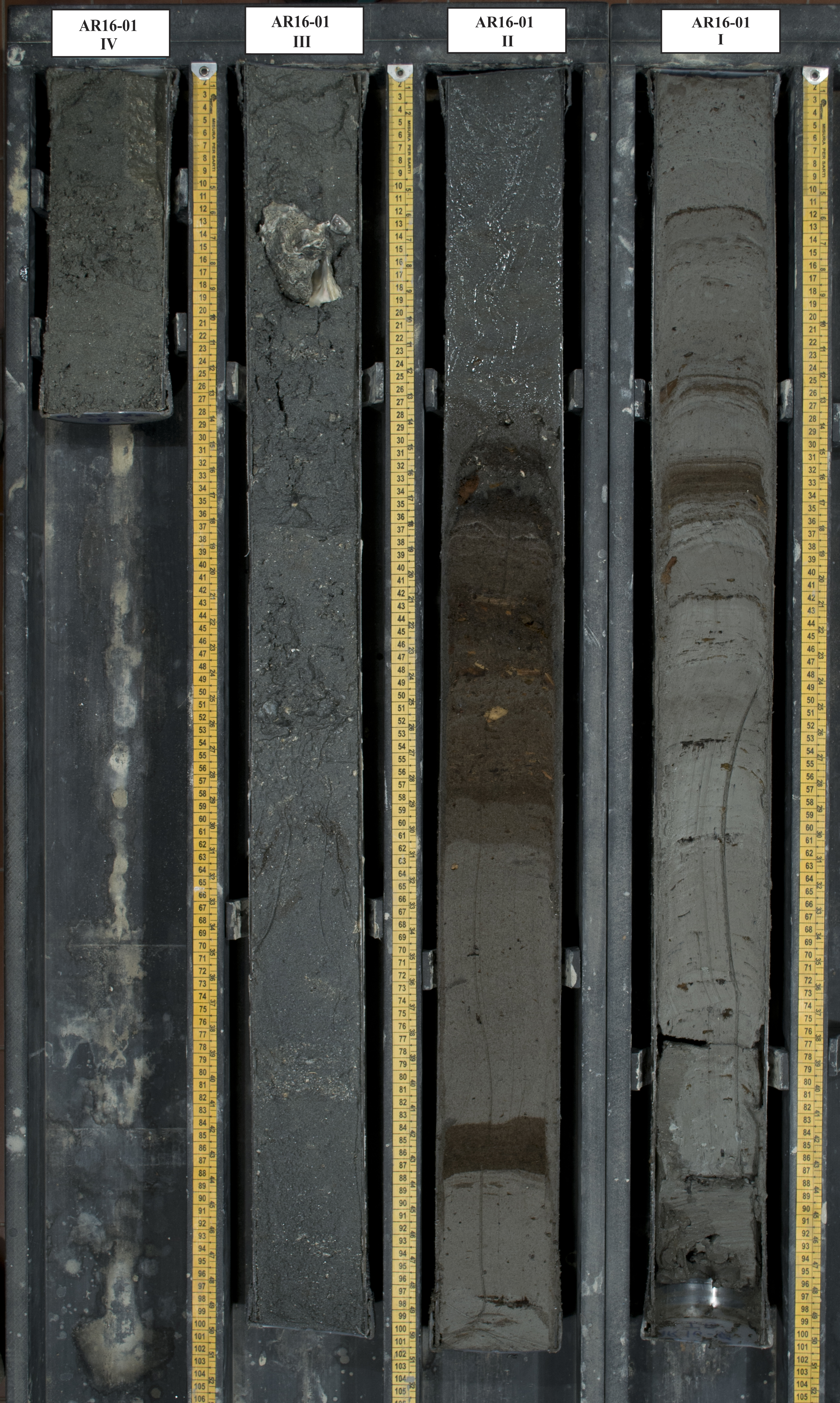
Core AR16-01
Sediment core "AR16-01" collected during the oceanographic cruise "AR16" by CNR-ISMAR in The North Adriatic Sea (profondità: 38.50 m; dimensione carota recuperata: 3.25 m; spezzoni: xx; metà spezzoni: xx)
Base
- Data (Creazione)
- 2021-10-25
- Identificatore
- http://libeccio.bo.ismar.cnr.it:8080/geonetwork/srv/ita/catalog.search#/metadata/99c1ad4a-2cff-420b-8221-0b51f97cc36c / GEONETWORK
- Crediti
- © CNR-ISMAR
- Status
- Completato
Ricercatore principale
National Research Council (CNR)
-
Annamaria Correggiari
(
Principal investigator
)
https://orcid.org/0000-0001-9820-5423
- Frequenza di aggiornamento
- Secondo necessità
- GEMET - INSPIRE themes, version 1.0
-
- Geology
- Continents, countries, sea regions of the world.
-
- Mediterranean Sea
- Adriatic Sea
- Italy
- Platform Type
-
- research vessel
- Survey type
-
- Geologic
- Campaign
-
- AR16
- Collection method
-
- Coring
- Device
-
- Vibro corer
- Sample type
-
- Core
- Material type
-
- Sediment
- Project
-
- ECORD
- DANUBIUS-RI
- Limitazione d’uso
- None
- Vincoli di fruibilità
- Licenza
- Altri vincoli
- CC-BY
- Vincoli di accesso
- Licenza
- Altri vincoli
- CC-BY
- Classificazione
- Non riservato
- Tipo di rappresentazione spaziale
- Dati vettoriali
- Lingua dei metadati
- English
- Set dei caratteri dei metadati
- UTF8
- Tema
-
- Informazioni geoscientifiche
- Descrizione
- Mediterranean Sea, Adriatic Sea, etc.
N
S
E
W
))
- Identificatore del sistema di riferimento
- EPSG:3857 - WGS84 Web Mercator (Auxiliary Sphere)
- Livello di topologia
- Solo Geometria
- Oggetto di tipo geometrico
- Punto
- Conteggio oggetto geometrico
- 1
- Formato di distribuzione
-
-
Shapefile
(
.shp
)
-
Shapefile
(
.shp
)
Distributore
National Research Council (CNR) - Institute of Marine Science (ISMAR)
http://www.ismar.cnr.it/
- Risorsa online
-
Web application
(
WWW:LINK-1.0-http--link
)
ISMAR Spatial Database - Web application
- Risorsa online
-
Data
(
WWW:DOWNLOAD-1.0-http--download
)
high resolution images, log, susceptibility, x-ray, xrf analysis
- Livello
- Dataset non geografici
- Dataset
- Core
Conformità
- Data (Pubblicazione)
- 2020-10-09
- Spiegazione
- Validated in Geonetwork according to the ISO19115 rules (25/25) and the INSPIRE rules (30/30)
- Pass
- Yes
- Genealogia del dato – Processo di produzione
- Core collected in the Nord Adriatic Sea (Emilia-Romagna Region) during the oceanographic cruise AR16 on board of the ship "OPENMAR I" in the framework of the agreement CNR-ISMAR - ARPAE for the project "Messa insicurezza di tratti critici del litorale regionale mediante ripascimento con sabbie sottomarine - Progettone 3". The survey was performed by "Geopolaris srlu" on behalf of ARPA Emilia Romagna - Servizio Idro-Meteo-Clima
- Descrizione
- Processing on the resource
- Identificatore del file di metadati
- 99c1ad4a-2cff-420b-8221-0b51f97cc36c XML
- Lingua dei metadati
- English
- Set dei caratteri dei metadati
- UTF8
- Livello gerarchico
- Dataset
- Nome del livello gerarchico
- Core
- Data dei metadati
- 2024-06-26T13:58:57
- Nome dello Standard dei metadati
- ISO 19115:2003/19139
- Versione dello Standard dei metadati
- 1.0