CNR-ISMAR
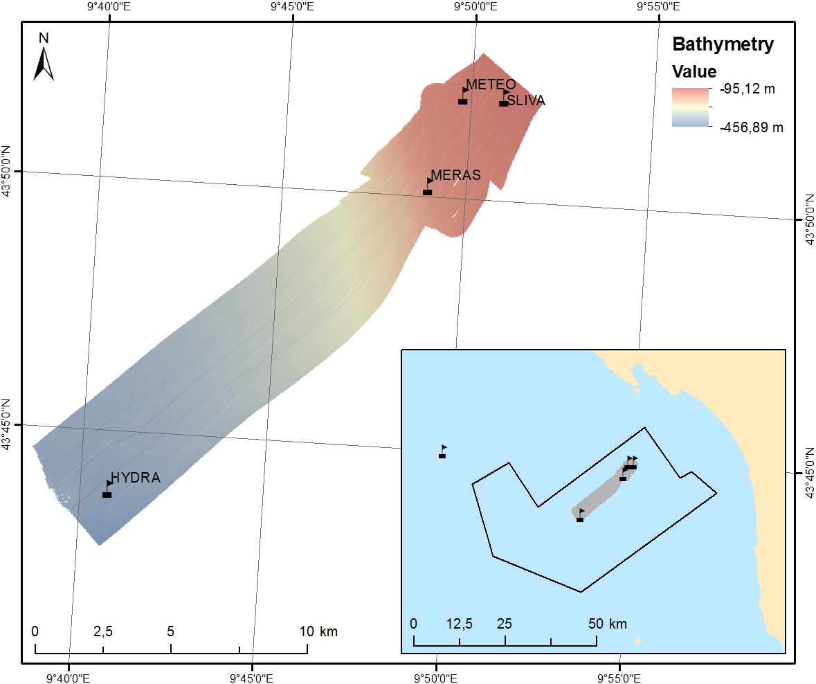
LOGMEC17 bathymetry & backscatter
Rilievo batimetrico tramite EM302 durante la campagna oceanografica a bordo della Nave Alliance in Mar Tirreno Mar Ligure dal 26/09/2017 al 30/09/2017 per rilievo oceanografico / idrologico “MREA 17” con deploy del ASV-Wave-glider (Regione Toscana) e monitoraggio parametri ambientali e correntometrici nell'ambito del progetto LOGMEC il quale prevedeva:
- una prima fase di misurazioni con sonda CTD e ADCP nel Tirreno Settentrionale e Centrale, con personale dell’Istituto in T.I.;
- rilievo idrografico, volto a un mooring al largo di Marina di Carrara;
- messa a mare e recupero di un drifter con perso- nale del Lamma Toscana in T.I.;
- misurazioni CTD e ADCP con personale del CMCC e CNR in T.I. al largo di Marina di Carrara.
Simple
- Date (Creation)
- 2022-08-09
- Identifier
- http://libeccio.bo.ismar.cnr.it:8080/geonetwork/srv/eng/catalog.search#/metadata/92f4f7fa-2dd2-4ab6-b522-b4e4baf185c4 / GEONETWORK
- Unique resource identifier
- none
- Credit
- © LOGMEC Project
- Status
- Completed
- Maintenance and update frequency
- As needed
- GEMET - INSPIRE themes, version 1.0
-
- Hydrography
- Survey type
-
- Geophysics
- Hydrology
- Collection method
-
- Sonar system
- Device
-
- Multibeam
- Swath type
-
- Bathymetry
- Seabed reflectivity
- Continents, countries, sea regions of the world.
-
- Tyrrhenian Sea
- Italy
- Mediterranean Region
- Ligurian Sea
- Use limitation
- None
- Use constraints
- Other restrictions
- Other constraints
- LOGMEC data policy
- Access constraints
- Other restrictions
- Other constraints
- By negotiation
- Classification
- Restricted
- Spatial representation type
- Vector
- Metadata language
- English
- Character set
- UTF8
- Topic category
-
- Elevation
Extent
- Description
- mediterranean sea

Extent
- Begin date
- 2017-09-26
- End date
- 2017-09-28
- Supplemental Information
- none
- Reference system identifier
- EPSG:3857 - WGS84 Web Mercator (Auxiliary Sphere)
- Topology level
- Geometry only
- Geometric object type
- Surface
- Geometric object count
- 1
- Distribution format
-
-
Shapefile
(
.shp
)
-
ESRI GRID
(
.asc
)
- Specification
- NAS ISMAR Bologna
-
Shapefile
(
.shp
)
- Hierarchy level
- Dataset
- Dataset
- Bathymetric surface
Conformance result
- Date (Publication)
- 2020-10-09
- Explanation
- Validated in Geonetwork according to the ISO19115 rules (25/25) and the INSPIRE rules (30/30)
- Pass
- Yes
- File identifier
- 92f4f7fa-2dd2-4ab6-b522-b4e4baf185c4 XML
- Metadata language
- English
- Character set
- UTF8
- Hierarchy level
- Dataset
- Date stamp
- 2022-08-09T16:07:22
- Metadata standard name
- ISO 19115:2003/19139
- Metadata standard version
- 1.0