 CNR-ISMAR
Survey BS77-I
Crociera BS77-I
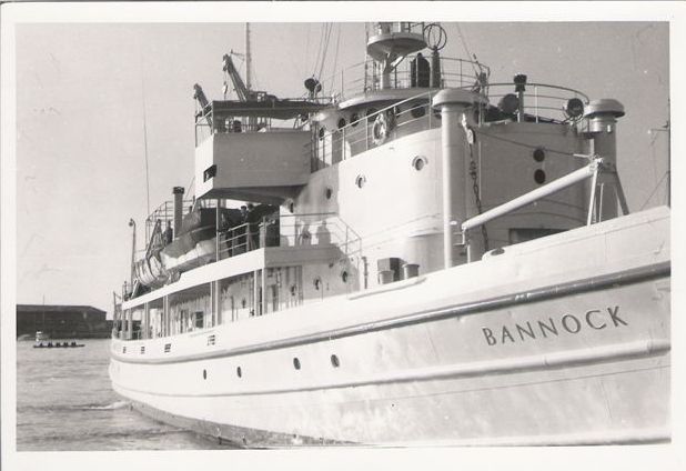
The survey has been carried out on board of the R/V Bannock - CNR. During the cruise, main aim of which was the tectonics and stratigraphic reconstruction of the eastern continental slope of Sardinia, a grid of single channel seismic profiles was collected using a 30 kJ - Sparker source (Teledyne Exploration, Houston - USA). From the original radio navigation system Loran-C, the coordinates have been later converted into geographical. The sparker profiles total 560 nm. The areas investigated during the survey BS77-I are: the eastern continental slope of Sardinia (seismic profiles BS), and the continental shelf sourrounding the Giglio Island (seismic profiles BS77-AT). The cruise has been carried out during two periods, one corresponding to the 4th - 30Th of April 1977 and the other to the 5th – 10Th of April 1976. Dr. Nevio Zitellini was part of the scientific team, A. Ferriani was part of the technical team. PI was the Dr. XXX.
L'acquisizione in mare è stata effettuata con la nave Bannock del CNR. Durante questa crociera, il cui principale scopo fu quello di definire l’assetto tettono-stratigrafico della scarpata orientale della Sardegna, sono stati acquisiti diversi profili sismici monocanale con lo Sparker-30 kJ della Teledyne Exploration di Houston (USA). Il sistema di navigazione utilizzato è stato il Loran C, e le coordinate sono state successimene convertite in geografiche. Sono stati registrati in totale 560 MN (miglia nautiche). Le aree investigate durante il rilievo BS77-I sono le seguenti: la scarpata orientale della Sardegna (profii sismici BS77-BS); e la piattaforma continentale nell’intorno dell’Isola del Giglio (profili sismici BS77-AT). I rilievi sono stati effettuati in due momenti diversi, una dal 4 al 30 Aprile 1977 e l’altra dal 5 al 10 Aprile 1976. A bordo era presente il Dr. Nevio Zitellini come parte del personale scientifico, e il A. Ferriani parte del team tecnico. Capo crociera Dr. XXX.
Simple
-
Data (Creazione)Date (Creation)
- 2020-11-30
-
IdentificatoreIdentifier
- http://libeccio.bo.ismar.cnr.it:8080/geonetwork/srv/ita/catalog.search#/metadata/91bab6f6-acbe-4664-afa6-e9c15620a7bd
-
Formato di presentazionePresentation form
-
Documento digitaleDigital document
-
CreditCrediti
-
© CNR-ISMAR© CNR-ISMAR
-
StatusStatus
-
In corsoOn going
Fornitore della risorsa
Resource provider
ISMAR - CNR
ISMAR - CNR
-
M. Filomena Loreto
M. Filomena Loreto
(
x
)
-
Frequenza di aggiornamentoMaintenance and update frequency
-
Secondo necessitàAs needed
-
Survey
-
-
BS77BS77
-
-
Survey type
-
-
GeophysicsGeofisica
-
SeismicSismica
-
GeologyGeologia
-
-
Device
-
-
SparkerSparker
-
- Keywords
-
-
oceanographic cruisecrociera oceanografica
-
seismic surveyrivilevo sismico
-
-
GEMET - INSPIRE themes, version 1.0
-
-
GeologyGeologia
-
Natural risk zonesZone a rischio naturale
-
-
Use limitationLimitazione d’uso
-
nonenessuno
-
Vincoli di accessoAccess constraints
-
Altri vincoliOther restrictions
-
Other constraintsAltri vincoli
-
Data policy of the project (link)Data policy di progetto (link)
Vincoli sulla risorsa
Resource constraints
No information provided.
-
Vincoli di fruibilitàUse constraints
-
Altri vincoliOther restrictions
-
Other constraintsAltri vincoli
-
Data policy of the project (link)Data policy di progetto (link)
-
ClassificazioneClassification
-
Non riservatoUnclassified
-
Lingua dei metadatiMetadata language
- Italiano
-
TemaTopic category
-
-
Informazioni geoscientificheGeoscientific information
-
N
S
E
W
))
-
Supplemental InformationInformazioni supplementari
-
Tyrrhenian Sea, Western SardiniaMar Tirreno, Sardenia Occidentale
-
Formato di distribuzioneDistribution format
-
-
PDFPDF( .pdf )
-
-
LivelloHierarchy level
-
Dataset non geograficiNon geographic dataset
- Other
- Report
Conformità
Conformance result
-
Data (Revisione)Date (Revision)
- 2020-11-30
-
Explanation
-
Validated in Geonetwork according to the ISO19115 rules (24/24)
-
PassPass
- Yes
-
StatementGenealogia del dato – Processo di produzione
-
The cruise report was produced in 1977Report di campagna prodotto nel 1973
-
Identificatore del file di metadatiFile identifier
- 91bab6f6-acbe-4664-afa6-e9c15620a7bd XML
-
Lingua dei metadatiMetadata language
- English
-
Set dei caratteri dei metadatiCharacter set
-
UTF8UTF8
-
Livello gerarchicoHierarchy level
-
DatasetDataset
- Hierarchy level name
- Report
-
Data dei metadatiDate stamp
- 2022-07-25T17:18:42
- Metadata standard name
- ISO 19115:2003/19139
- Metadata standard version
- 1.0
Overviews


Spatial extent
N
S
E
W
Provided by

Associated resources
Not available