CNR-ISMAR
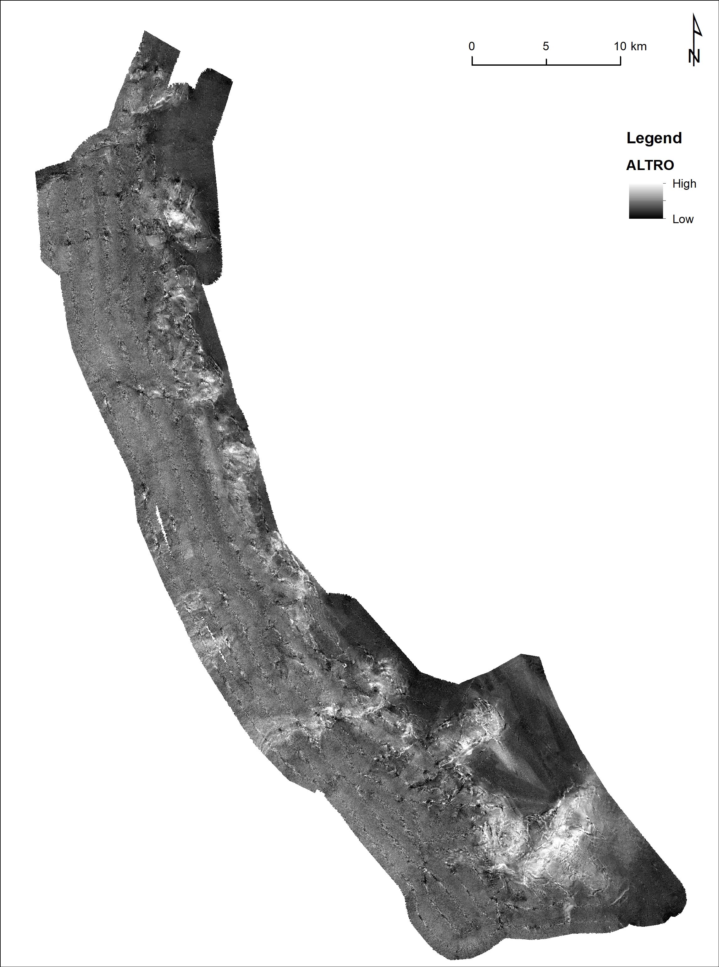
ALTRO backscatter
The data have been acquired with a Simrad EM710 multi beam echosounder hull-mounted on board the R/V URANIA in the framework of COCONET project to map the submerged landscape off shore Montenegro. The aim of the survey was to map benthic habitats on the continental shelf and slope, focusing on cold water corals occurrences.
Simple
- Date (Creation)
- 2021-04-20
- Identifier
- http://libeccio.bo.ismar.cnr.it:8080/geonetwork/srv/ita/catalog.search#/metadata/61b97f61-c059-42e0-b251-92f560a740b4 / GEONETWORK
- Unique resource identifier
- EMODnet Global CDI ID 2510140; EMODnet LOCAL:CNR-ISMAR-82
- Credit
- © CNR-ISMAR
- Status
- On going
Principal investigator
National Research Council (CNR)
-
Marco Taviani
(
Researcher
)
Bologna
,
Italy
https://orcid.org/0000-0003-0414-4274
Principal investigator
National Research Council (CNR)
-
Lorenzo Angeletti
(
Researcher
)
https://orcid.org/0000-0003-3159-2400
- Maintenance and update frequency
- As needed
- GEMET - INSPIRE themes, version 1.0
-
- Elevation
- Geology
- Survey type
-
- Geophysics
- Cartography
- Collection method
-
- Sonar system
- Device
-
- Multibeam
- Swath type
-
- Seabed reflectivity
- Campaign
-
- ALTRO
- Project
-
- CoCoNet
- Continents, countries, sea regions of the world.
-
- Mediterranean Region
- Adriatic Sea
- Montenegro
- Use limitation
- None
- Use constraints
- License
- Other constraints
- CC-BY
- Access constraints
- Other restrictions
- Other constraints
- By request
- Classification
- Restricted
- Aggregate Datasetindentifier
- c99842cc-6e46-4dc0-8871-cfb4519a1a82
- Association Type
- Larger work citation
- Initiative Type
- Project
- Aggregate Datasetindentifier
- f548718f-ac6a-47d0-b373-fcb451e34ebc
- Association Type
- Larger work citation
- Initiative Type
- Project
- Spatial representation type
- Vector
- Metadata language
- Italiano
- Character set
- UTF8
- Topic category
-
- Elevation
- Geoscientific information
Extent
- Description
- mediterranean sea; eastern basin; adriatic sea

Extent
- Begin date
- 2012-12-29
- End date
- 2013-01-09
- Supplemental Information
- none
- Reference system identifier
- EPSG:3857 - WGS84 Web Mercator (Auxiliary Sphere)
- Topology level
- Geometry only
- Geometric object type
- Surface
- Geometric object count
- 1
- Distribution format
-
-
Shapefile
(
.shp
)
-
ESRI GRID
(
.asc
)
- Specification
- NAS ISMAR Bologna
-
Shapefile
(
.shp
)
Distributor
National Research Council (CNR) - Institute of Marine Science (ISMAR)
http://www.ismar.cnr.it/
- OnLine resource
-
Web application
(
WWW:LINK-1.0-http--link
)
ISMAR Spatial Database - Web application
- OnLine resource
-
Backscatter ALTRO
(
WWW:LINK-1.0-http--link
)
Grid
- Hierarchy level
- Dataset
- Dataset
- Seafloor reflectivity
Conformance result
- Date (Publication)
- 2020-10-09
- Explanation
- Validated in Geonetwork according to the ISO19115 rules (25/25) and the INSPIRE rules (30/30)
- Pass
- Yes
- Statement
- The data have been acquired with a Simrad EM710 multi beam echosounder hull-mounted on board the R/V URANIA in the framework of COCONET project to map the submerged landscape off shore Montenegro. The aim of the survey was to map benthic habitats on the continental shelf and slope, focusing on cold water corals occurrences.
- Description
- Processed by CNR-ISMAR with the software CARIS v. xx
- File identifier
- 61b97f61-c059-42e0-b251-92f560a740b4 XML
- Metadata language
- English
- Character set
- UTF8
- Parent identifier
- Survey ALTRO 4360e732-432a-4ee5-a9b2-03f2e837d254
- Hierarchy level
- Dataset
- Date stamp
- 2022-09-28T16:14:21
- Metadata standard name
- ISO 19115:2003/19139
- Metadata standard version
- 1.0