 CNR-ISMAR
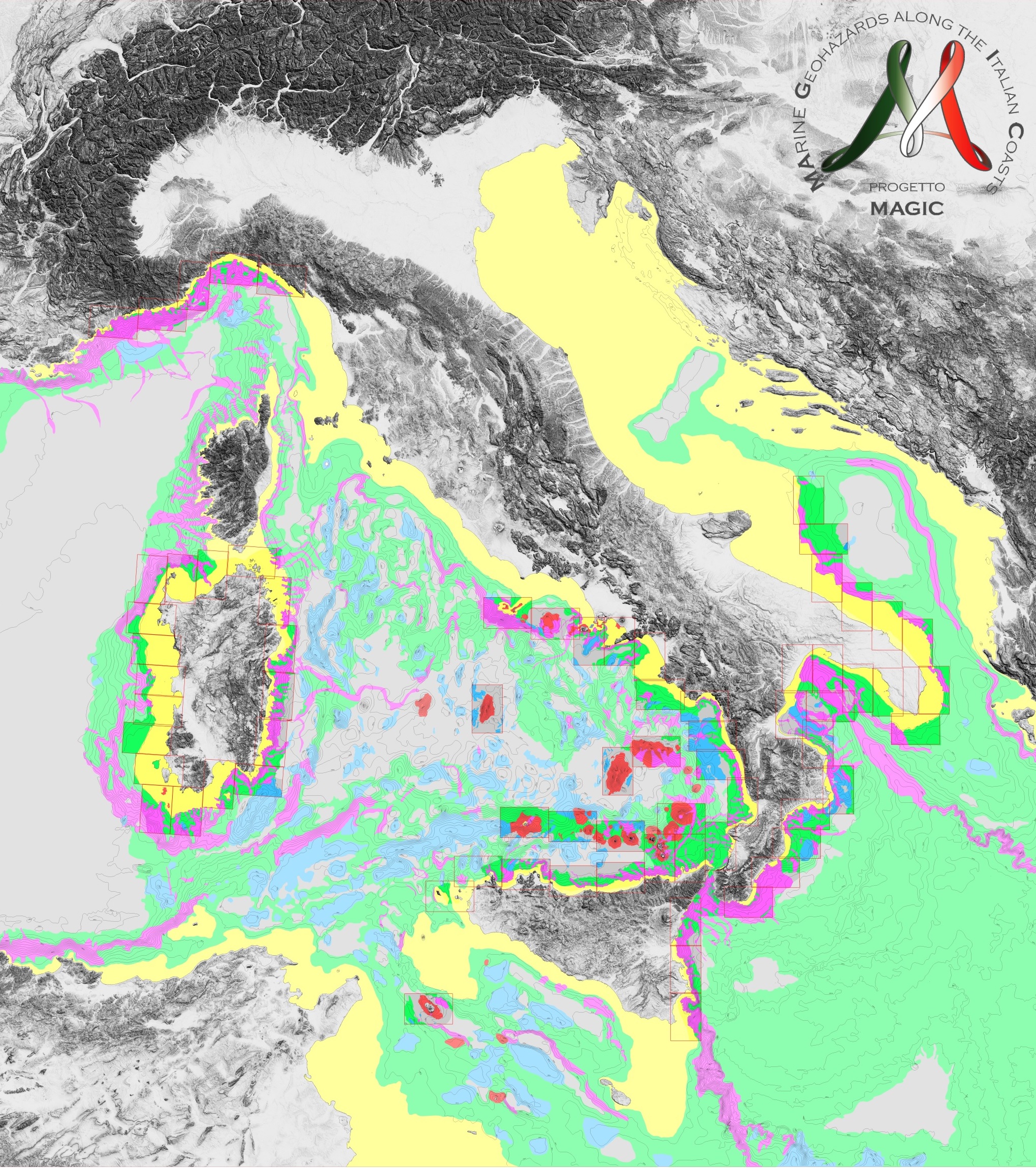
Level 2 - Morphological units - Project MAGIC
Shapefile of Level 2: Morphological Units. They represent large units in which there are different morphobathymetric elements (Level 3) whose predominance is characterising and indicative of certain geological processes or phenomena. Original metadata sheet:
http://dati.protezionecivile.it/geoportalDPC/catalog/search/resource/details.page?uuid=PCM_MaGIC1_17%3A20160627%3A125032
Simple
- Date (Creation)
- 2022-07-21
- Credit
- Civil Protection Department (Italian Government)
- Status
- Completed
Resource provider
National Research Council - Istitute of Marine Sciences (CNR-ISMAR)
-
Mariacristina Prampolini
(
Post doc
)
https://orcid.org/0000-0002-0408-4411
- Maintenance and update frequency
- As needed
- Keywords
-
- Marine geology
- Physical oceanography
- Hazard area
- nbfc
- GEMET - INSPIRE themes, version 1.0
-
- Natural risk zones
- Oceanographic geographical features
- Use limitation
- None
- Use constraints
- Other restrictions
- Other constraints
- https://creativecommons.org/licenses/by/4.0/
- Access constraints
- Other restrictions
- Other constraints
- https://creativecommons.org/licenses/by/4.0/
- Classification
- Unclassified
- Spatial representation type
- Vector
- Denominator
- 50000
- Metadata language
- Italiano
- Character set
- UTF8
N
S
E
W
))
- Supplemental Information
- Any other descriptive information about the dataset
- Reference system identifier
- WGS1984
Spatial representation info
No information provided.
- Topology level
- Geometry only
- Geometric object type
- Surface
- Geometric object count
- 1
- Distribution format
-
-
Shapefile
(
e. g.. v1.0
)
-
Shapefile
(
e. g.. v1.0
)
- Hierarchy level
- Dataset
- Dataset
- Dataset
Conformance result
- Date (Publication)
- 2020-10-09
- Explanation
- Validated in Geonetwork according to the ISO19115 rules (25/25) and the INSPIRE rules (30/30)
- Pass
- Yes
- Statement
- This dataset was produced within the Project MAGIC and was downloaded at the following link https://github.com/pcm-dpc/MaGIC on the 22/07/2022. More details available at http://dati.protezionecivile.it/geoportalDPC/catalog/search/resource/details.page?uuid=PCM_MaGIC1_17%3A20160627%3A125032
- File identifier
- 5e30554a-7c5b-40d3-a2bf-199ea5a8cd32 XML
- Metadata language
- English
- Character set
- UTF8
- Parent identifier
- MAGIC Project - MArine Geohazard along the Italian Coast 31cbb959-c331-49f0-b086-0c64aa707dee
- Hierarchy level
- Dataset
- Date stamp
- 2023-12-06T09:52:53
- Metadata standard name
- ISO 19115:2003/19139
- Metadata standard version
- 1.0
Overviews
Spatial extent
N
S
E
W
Provided by

Associated resources
Not available