CNR-ISMAR
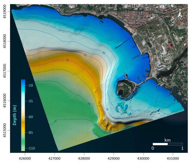
Bathymetry ABBaCo - Bagnoli
Bathymetric dataset collected in the frame of the research project ABBaCO (Environmental Restoration of the Bagnoli-Coroglio National Site of Interest). The Project was aimed to support planning actions for the restoration of marine habitats of the Bagnoli-Coroglio area, characterized by the presence of a large industrial site from 1910 until the 1990s.
Bathymetric data were collected by means of a Teledyne Reson SeaBat 7125 multibeam echosounder and processed using PDS 4.1 (Teledyne©inc) editing software.
Base
- Data (Pubblicazione)
- 2020
- Identificatore
-
https://doi.org/10.1080/02757540.2020.1735373
- Data (Pubblicazione)
- 2020-07-02
- Altri dettagli
- How to cite this data: Di Martino Gabriella , Innangi Sara , Passaro Salvatore , Sacchi Marco , Vallefuoco Mattia & Tonielli Renato (2020) Mapping of seabed morphology of the Bagnoli brownfield site, Pozzuoli (Napoli) Bay, Italy, Chemistry and Ecology, 36:6, 496-510, DOI: 10.1080/02757540.2020.1735373
- Identificatore
-
http://libeccio.bo.ismar.cnr.it:8080/geonetwork/srv/eng/catalog.search#/metadata/4f4556e3-5d01-4a15-ae69-03cd8ab81998
- Data (Pubblicazione)
- 2024-10-18
- Crediti
- © CNR-ISMAR
- Status
- Completato
- Frequenza di aggiornamento
- Secondo necessità
- GEMET - INSPIRE themes, version 1.0
-
- Geology
- Continents, countries, sea regions of the world.
-
- Mediterranean Sea
- Tyrrhenian Sea
- Italy
- Platform Type
-
- research vessel
- Survey type
-
- Geophysics
- Cartography
- Collection method
-
- Sonar system
- Device
-
- Multibeam
- Swath type
-
- Bathymetry
- Parole chiave
-
- ABBaCo Project
- gulf of Pozzuoli
- Limitazione d’uso
- Do not use for navigation
- Vincoli di fruibilità
- Licenza
- Altri vincoli
- CC BY NC 4.0
- Vincoli di accesso
- Licenza
- Altri vincoli
- CC BY NC 4.0
- Classificazione
- Non riservato
- Tipo di rappresentazione spaziale
- Dati raster
- Lingua dei metadati
- English
- Set dei caratteri dei metadati
- UTF8
- Tema
-
- Quote e prodotti derivati
- Informazioni geoscientifiche
Estensione

Estensione
- Data di inizio
- 2017-06-01
- Data di fine
- 2017-06-15
- Informazioni supplementari
- none
- Identificatore del sistema di riferimento
- EPSG:32633 - WGS 84 / UTM zone 33N
- Livello di topologia
- Solo Geometria
- Oggetto di tipo geometrico
- Superficie
- Conteggio oggetto geometrico
- 1
- Formato di distribuzione
-
-
ESRI GRID
(
)
-
GeoTIFF
(
.tif
)
-
ASCII
(
.asc
)
-
ESRI GRID
(
)
- Risorsa online
-
Scientific paper
(
DOI
)
Innangi et al., 2020
- Risorsa online
-
Scientific paper
(
DOI
)
Innangi et al., 2022
- Risorsa online
-
Scientific paper
(
DOI
)
Di Martino et al., 2021
- Risorsa online
-
Scientific paper
(
DOI
)
Di Martino et al., 2020
- Livello
- Modello
- Dataset
- Bathymetric surface
Conformità
- Data (Pubblicazione)
- 2023-07-01
- Spiegazione
- Validated in Geonetwork according to the ISO19115 rules (25/25) and the INSPIRE rules (30/30)
- Pass
- Yes
- Genealogia del dato – Processo di produzione
- Data were acquired by ISMAR-CNR, Napoli, within of the research project ABBaCo coordinated by the SZN Anton Dohrn, Napoli (SNZ-CNR contract n. 2974).
- Identificatore del file di metadati
- 4f4556e3-5d01-4a15-ae69-03cd8ab81998 XML
- Lingua dei metadati
- English
- Set dei caratteri dei metadati
- UTF8
- Livello gerarchico
- Modello
- Nome del livello gerarchico
- Bathymetric surface
- Data dei metadati
- 2024-10-21T12:45:21
- Nome dello Standard dei metadati
- ISO 19115:2003/19139
- Versione dello Standard dei metadati
- 1.0