CNR-ISMAR
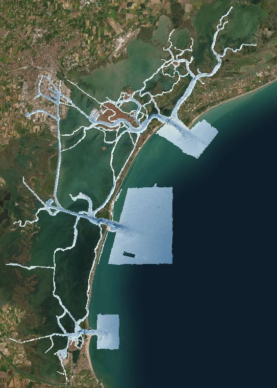
High resolution bathymetry of the Venice Lagoon
This dataset contains high-resolution ASCII:ESRI gridded bathymetric data (0.5 m DTM). Data was collected during a six-months survey (lasting from May to December 2013) in the channel network of the Venice Lagoon by means of the MBES system Kongsberg EM-2040 Compact dual head. The MBES was mounted on a pole at the bow of the CNR research vessel Litus, a 10-m long boat with only 1.5-m draft. The MBES has 800 beams (400 per swath) 1°x1°; the operational frequency for this survey was set at 360 kHz. A Seapath 300 system was used for ship positioning, improving its accuracy by the correction provided by a Fugro HP differential Global Positioning System (DGPS, accurate up to 0.2 m). Tidal correction of bathymetric data was based on a set of virtual tidal stations (93 points) distributed evenly around all the study area. The tidal corrections in each virtual tide gauge station were calculated using the water level simulated by the hydrodynamic model SHYFEM (Umgiesser et al., 2014) applied to the whole Venice Lagoon. Data was processed after collected using CARIS to account for sound velocity profiles, tide corrections, and manual quality control tools. The base surfaces were created with the Swath Angles Weighting option with a Max Footprint size of 9x9 pixels and a resolution of 0.5 m and cleaned using the subset editor to efficiently handle and visualize. The raw data are stored in the CNR-ISMAR Venice server and available under request to data owner. Data collection have been founded thanks to the Italian Italian Flagship Project RITMARE. The datafile iim_malamocco.asc was collected by the Italian hydrographic Institute (IIM Istituto Idrografico della Marina) by means of the MBES system Kongsberg EM3002 on board of the vessels MBN1148 and MBF1213. The Italian Hydrographic Institute processed the bathymetric using CARIS HIPS AND SIPS 7.1.
Base
- Data (Creazione)
- 2016-12-11
- Data (Pubblicazione)
- Identificatore
- http://libeccio.bo.ismar.cnr.it:8080/geonetwork/srv/eng/catalog.search#/metadata/27f8563b-c454-45b8-b146-562de2e7f769 / GEONETWORK
- Data (Pubblicazione)
- Identificatore unico di risorsa
- http://get.iedadata.org/doi/323605
- Data (Pubblicazione)
- 2022-09-21
- Identificatore unico di risorsa
- https://sextant.ifremer.fr/record/SDN_CPRD_145_DTM_CNR-ISMAR-124/
- Altri dettagli
- Madricardo, Fantina, et al., (2017), Processed high-resolution ASCII:ESRI gridded bathymetry data (EM2040 and EM3002) from the Lagoon of Venice collected in 2013. Interdisciplinary Earth Data Alliance (IEDA). doi:10.1594/IEDA/323605
- Crediti
- © CNR-ISMAR
- Status
- Completato
Punto di contatto
No information provided.
Ricercatore principale
National Research Council (CNR) - Institute of Marine Science (ISMAR)
-
Fantina Madricardo
(
Researcher
)
Arsenale Castello, 2737/F,
,
Vanice
,
30122
,
https://orcid.org/0000-0002-9474-3491
Ricercatore principale
National Research Council (CNR) - Institute of Marine Science (ISMAR)
-
Foglini Federica
(
Technologist
)
Via Gobetti 101
,
Bologna
,
40129
,
https://orcid.org/0000-0002-2736-0052
Ricercatore principale
National Research Council (CNR) - Institute of Marine Science (ISMAR)
-
Fabio Trincardi
(
)
https://orcid.org/0000-0002-8476-8804
- Frequenza di aggiornamento
- Secondo necessità
- Name
- ASCII:ESRI gridded bathymetry data
- Versione formato
- .asc
- GEMET - INSPIRE themes, version 1.0
-
- Elevation
- Continents, countries, sea regions of the world.
-
- Adriatic Sea
- Platform Type
-
- research vessel
- Survey type
-
- Geophysics
- Cartography
- Campaign
-
- VENICE2013
- Collection method
-
- Sonar system
- Device
-
- Multibeam
- Swath type
-
- Bathymetry
- Parole chiave
-
- river-sea system
- Limitazione d’uso
- DO NOT USE FOR NAVIGATION
- Vincoli di fruibilità
- Licenza
- Altri vincoli
- Creative Commons Attribution 4.0 International Public License [CC BY 4.0] URI: https://creativecommons.org/licenses/by/4.0/
- Vincoli di accesso
- Licenza
- Altri vincoli
- Creative Commons Attribution 4.0 International Public License [CC BY 4.0] URI: https://creativecommons.org/licenses/by/4.0/
- Classificazione
- Non riservato
- Tipo di rappresentazione spaziale
- Dati raster
- Denominatore
- 5000
- Lingua dei metadati
- English
- Set dei caratteri dei metadati
- UTF8
- Tema
-
- Quote e prodotti derivati
Estensione

Estensione
- Data di inizio
- 2013-05-01
- Data di fine
- 2013-12-31
- Identificatore del sistema di riferimento
- EPSG:32633 - WGS 84 / UTM zone 33N
- Livello di topologia
- Solo Geometria
- Oggetto di tipo geometrico
- Superficie
- Conteggio oggetto geometrico
- 17
- Formato di distribuzione
-
-
Web Map Service
(
WMS
)
-
ASCII: ESRI GRID
(
.asc
)
-
Web Map Service
(
WMS
)
Distributore
National Research Council (CNR) - Institute of Marine Science (ISMAR)
http://www.ismar.cnr.it/
- Risorsa online
-
WMS
(
OGC:WMS-1.3.0-http-get-map
)
Web Map Service - ISMAR Geophysical products
- Risorsa online
- Related datasets ( WWW:LINK-1.0-http--link )
- Risorsa online
- Resource download ( WWW:LINK-1.0-http--link )
- Livello
- Dataset
- Dataset
- Bathymetric surface
Conformità
- Data (Pubblicazione)
- 2023-11-28
- Spiegazione
- Validated in Geonetwork according to the ISO19115 rules (25/25) and the INSPIRE rules (30/30)
- Pass
- Yes
- Genealogia del dato – Processo di produzione
- The multibeam system was pole-mounted on the CNR research vessel Litus. The MBES has 800 beams (400 per swath) 1° × 1°; the operational frequency for this survey was set at 360 kHz. A Seapath 300 system was used for ship positioning, supplied by a Fugro HP DGPS, accurate up to 0.2 m. The Kongsberg motion sensor MRU 5 and a Dual Antenna GPS integrated in the Seapath, corrected pitch, roll, heave and yaw movements (reaching 0.02° roll and pitch accuracy, and 0.075° heading accuracy). A Vale-port mini SVS sensor was attached close to the transducers to continuously measure the sound velocity for the beamforming. 640 sound velocity profiles were collected with an AML oceanographic Smart-X sound velocity profiler.
- Identificatore del file di metadati
- 27f8563b-c454-45b8-b146-562de2e7f769 XML
- Lingua dei metadati
- English
- Set dei caratteri dei metadati
- UTF8
- Livello gerarchico
- Dataset
- Nome del livello gerarchico
- Bathymetric surface
- Data dei metadati
- 2023-12-15T10:14:18
- Nome dello Standard dei metadati
- ISO 19115:2003/19139
- Versione dello Standard dei metadati
- 1.0