CNR-ISMAR
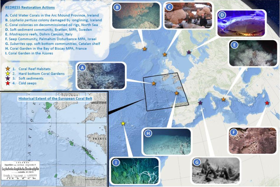
REDRESS - Active restoration area
Brief narrative summary of the content of the resource(s)
Base
- Data (Creazione)
- 2024-10-09
- Identificatore
- http://libeccio.bo.ismar.cnr.it:8080/geonetwork/srv/eng/catalog.search#/metadata/3996774b-3932-416a-8dd0-f4d619f5f6f0 / GEONETWORK
- Crediti
- © REDRESS Project
- Status
- Completato
Ricercatore principale
Polytechnic University of Marche
-
Roberto Danovaro
(
Project coordinator
)
https://www.webofscience.com/wos/author/record/M-9018-2014
- Frequenza di aggiornamento
- Secondo necessità
- Tema
-
- redress project
- deep-sea ecosystems
- ecosystem restoration
- deep-sea habitats
- good and services
- governance structure
- Continents, countries, sea regions of the world.
-
- Europe
- Balearic Sea
- Kattegat
- Mediterranean Sea, Eastern Basin
- Mediterranean Sea, Western Basin
- North Atlantic Ocean
- Skagerrak
- Tyrrhenian Sea
- Celtic Sea
- GEMET - INSPIRE themes, version 1.0
-
- Protected sites
- Area management/restriction/regulation zones and reporting units
- Habitats and biotopes
- Limitazione d’uso
- None
- Vincoli di fruibilità
- Licenza
- Altri vincoli
- CC-BY
- Vincoli di accesso
- Licenza
- Altri vincoli
- CC-BY
- Classificazione
- Non riservato
- Tipo di rappresentazione spaziale
- Dati vettoriali
- Lingua dei metadati
- English
- Set dei caratteri dei metadati
- UTF8
- Tema
-
- Confini
N
S
E
W
))
Estensione
- Data di inizio
- 2024-02-01
- Data di fine
- 2028-01-31
- Identificatore del sistema di riferimento
- EPSG:3857 - WGS84 Web Mercator (Auxiliary Sphere)
- Livello di topologia
- Solo Geometria
- Oggetto di tipo geometrico
- Superficie
- Conteggio oggetto geometrico
- 9
- Formato di distribuzione
-
-
Shapefile
(
.shp
)
-
Shapefile
(
.shp
)
Distributore
National Research Council (CNR) - Institute of Marine Science (ISMAR)
http://www.ismar.cnr.it/
- Risorsa online
-
REDRESS deep-sea restoration actions
(
OGC:WMS-1.3.0-http-get-map
)
Web Map Service (WMS)
- Risorsa online
-
REDRESS active restoration areas
(
WWW:DOWNLOAD-1.0-http--download
)
Shapefile
- Livello
- Dataset
- Dataset
- Dataset
Conformità
- Data (Pubblicazione)
- 2020-10-09
- Spiegazione
- Validated in Geonetwork according to the ISO19115 rules (25/25) and the INSPIRE rules (30/30)
- Pass
- Yes
- Genealogia del dato – Processo di produzione
- Shapefile produced in the framework of the REDRESS Project by CNR-ISMAR using ArcGIS Desktop.
- Descrizione
- Digitalization in ArcGIS Desktop (© ESRI)
- Data / Ora
- 2024-10-09T00:00:00
- Identificatore del file di metadati
- 3996774b-3932-416a-8dd0-f4d619f5f6f0 XML
- Lingua dei metadati
- English
- Set dei caratteri dei metadati
- UTF8
- Identificatore metadati di rango superiore
- REDRESS Geoportal 83a5b55c-0283-420d-83f1-3a66cbd6ef49
- Livello gerarchico
- Dataset
- Nome del livello gerarchico
- Dataset
- Data dei metadati
- 2024-10-09T16:07:57
- Nome dello Standard dei metadati
- ISO 19115:2003/19139
- Versione dello Standard dei metadati
- 1.0