 CNR-ISMAR
Shapefile
Type of resources
Topics
INSPIRE themes
Provided by
Years
Formats
Representation types
Update frequencies
status
Scale
-
da compialre..
-
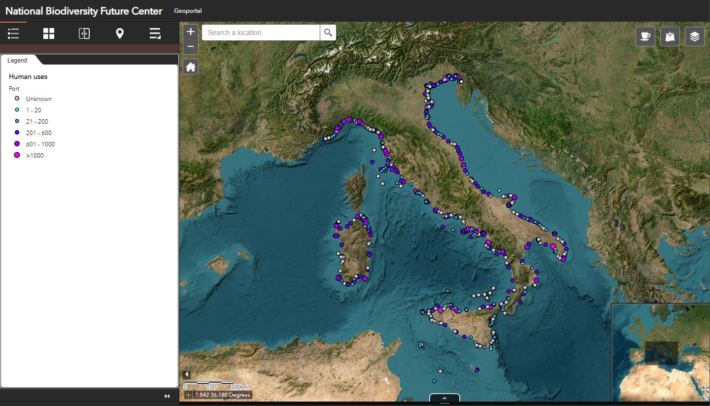
List of Italian ports divided by typology: TOURIST PORT: entirely dedicated to pleasure craft with a concession, It does not host commercial traffic. PUBLIC PORT: recreational places with more than one concession. Tourist and commercial motor ships arrive. If it is located in the city center or if it is not fenced. PORTICLE: small port with limited access due to draft or size and few services. PIERS: generally for boats < 10 m, but also for larger sizes. Usually floating, often seasonal, they may have places for pleasure. Even along the coast or on the beaches, not necessarily within a port. FIELD BUOYS: for boats <10 m. BOOTS: for boats >10 m. COMMERCIAL PORT: it hosts commercial and recreational traffic. CIRCLES: for the exclusive use of members of sailing clubs or clubs. They could host the port. PORT CHANNEL: along rivers and canals, it may have places for pleasure. WORKSITE: area dedicated to shipbuilding, could have places for pleasure craft MERCHANT PORT: for exclusive use of merchant and commercial traffic. They have no places for pleasure. MILITARY PORT: military area with no access. They have no places for pleasure. FISHING PORT: for the exclusive use of the fishing unit. They have no places for pleasure. EXCLUSIVE PORT: for the exclusive use of tourist complexes, private individuals or particular entities. They have no places for pleasure. PASSENGER TERMINAL: for the exclusive use of ships carrying passenger traffic. They have no places for pleasure. DOCK: usually hosts vessels, a small port without docks or an area within a larger port.
-
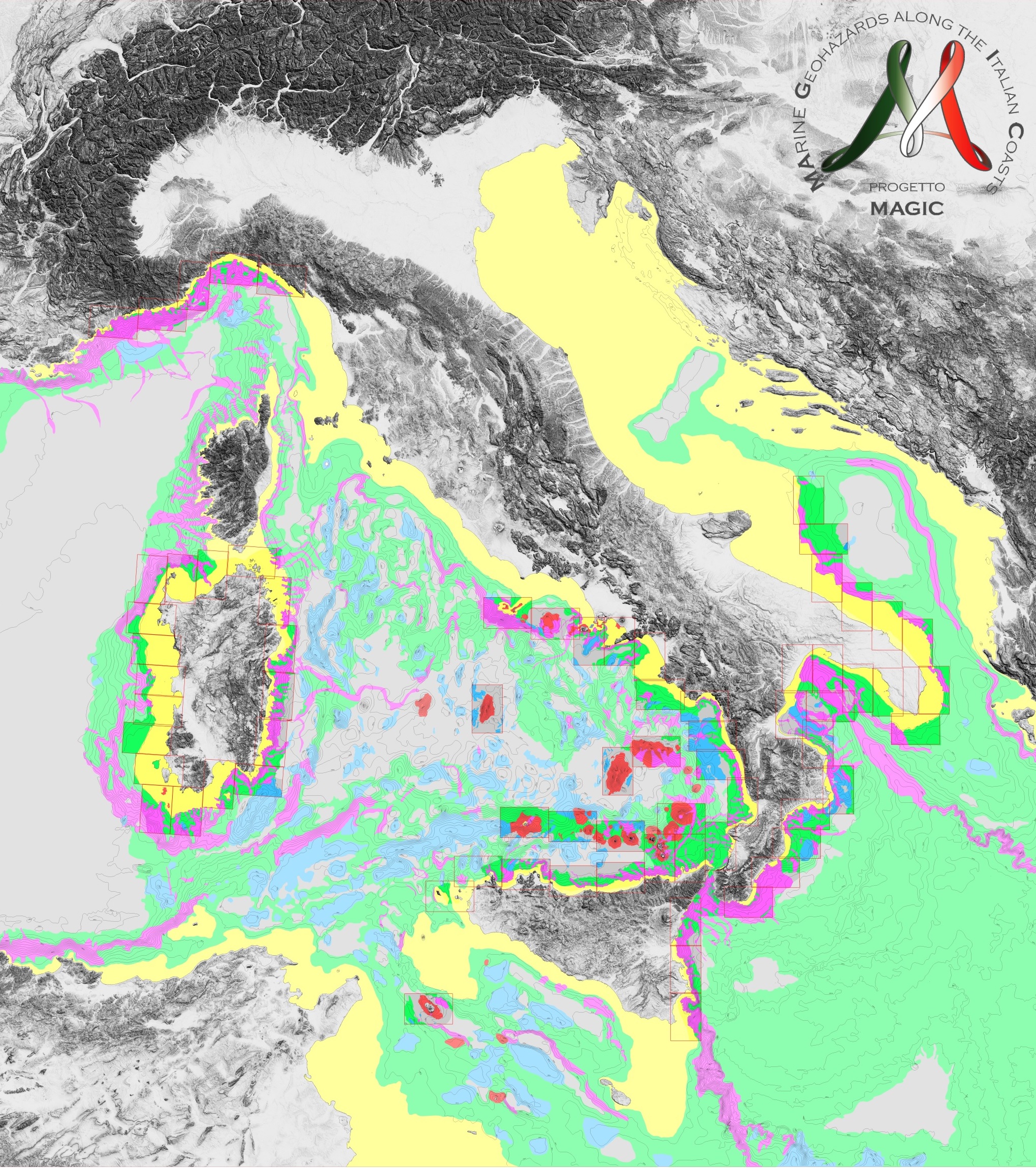
Quadro di unione dei 72 fogli che costituiscono la cartografia prodotta nell'ambito del Progetto MArine Geohazards along the Italian Coasts realizzato dai gruppi di ricerca italiani attivamente impegnati nel campo della Geologia Marinacon la partecipazione anche di un’unità dell’Università di Nizza. Alle 72 mappe, l'Università di Nizza ha aggiunto un'altra carta, relativa alla sua zona di sperimentazione. Scheda metadati originale: http://dati.protezionecivile.it/geoportalDPC/catalog/search/resource/details.page?uuid=PCM_MaGIC1_01%3A20160704%3A081100
-
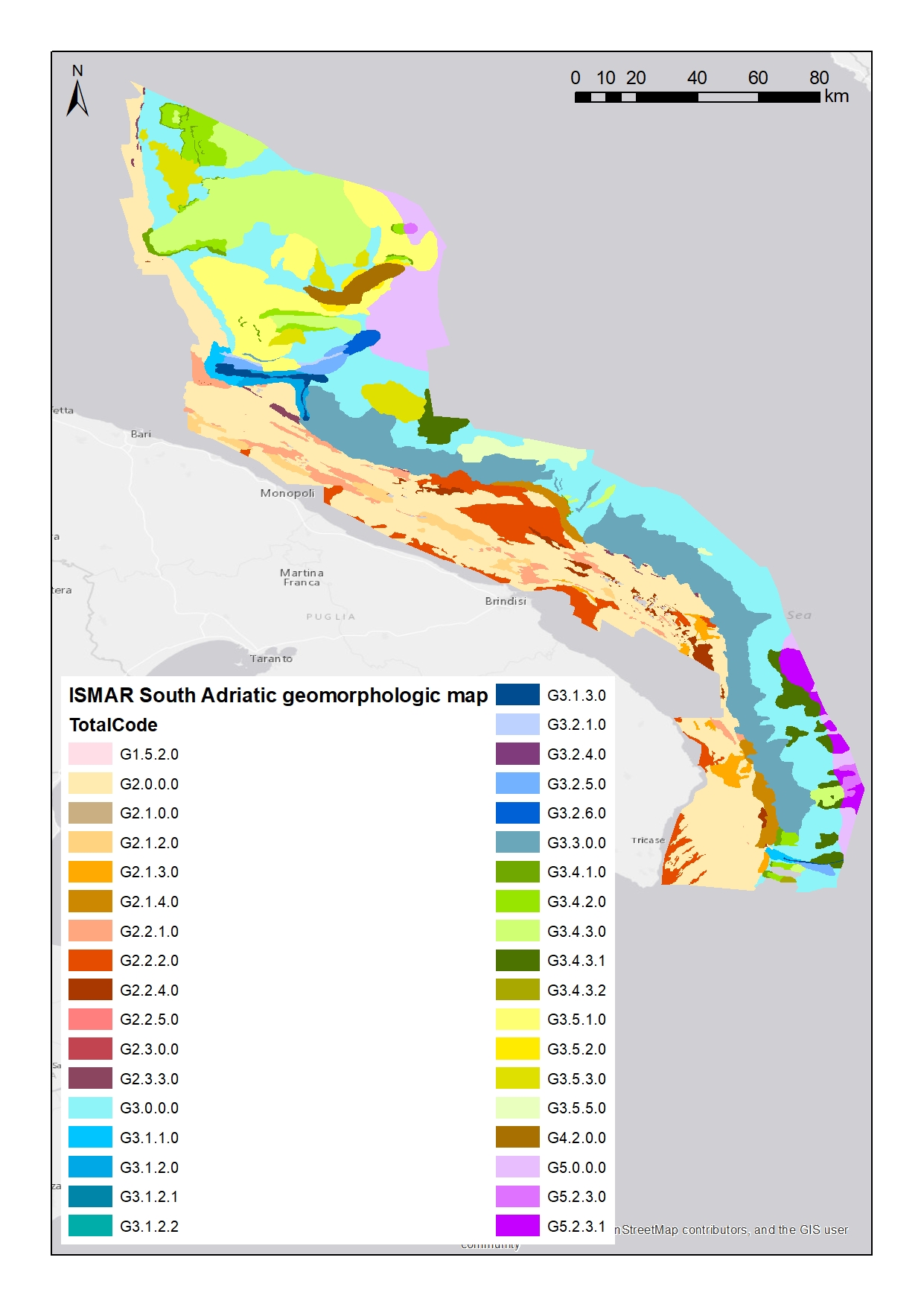
Shapefile del solo livello 2. Livello 2: Unità Morfologiche (UM) Rappresentano grandi unità all'interno delle quali si raggruppano tratti morfologici (EM del Livello 3) anche diversi ma la cui predominanza è caratterizzante e indicativa di determinati processi o fenomeni geologici. Scheda metadati originale: http://dati.protezionecivile.it/geoportalDPC/catalog/search/resource/details.page?uuid=PCM_MaGIC1_17%3A20160627%3A125032
-

OBIS is a global open-access data and information clearing-house on marine biodiversity for science, conservation and sustainable development. This dataset is a subset of the OBIS database, representing the records in the Italian waters.
-
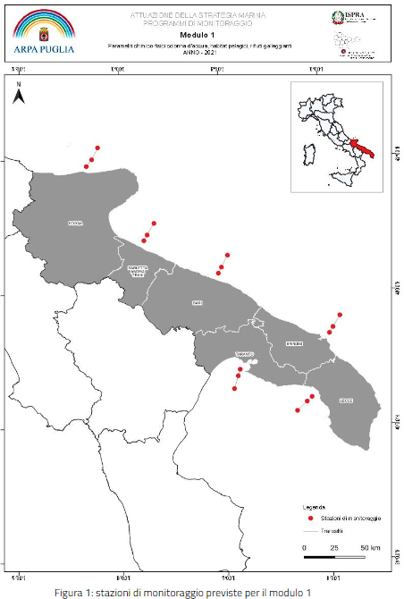
Distribution of the ARPA monitoring station along the Apulian coast in the framework of the Marine Strategy Framework Directive. Activities envisaged for monitoring the following elements: Module 1 – Chemical-physical parameters of the water column, pelagic habitats, floating waste Module 2 – Microplastics Module 3 – Non-native species Module 4 – Beached Waste Descriptor 5 – Eutrophication (activities carried out in modules 6A, 6F) Descriptor 8 - Contamination (sediments and biota) Module 7 – Coralligenous habitat Module 8 – Habitat of the funds in Rodoliti Module 9 – Seabed habitat subjected to physical damage Module 10 – Habitat of Posidonia oceanica meadows
-
ORMEF is a free, online searchable database about Mediterranean Exotic Fishes. It provides updated geo-referenced information for scientists, conservationists and policy makers, disseminating specialist’s knowledge and experience to a broad audience. This dataset is a subset of the ORMEF database, representing the records in the Italian waters.
-
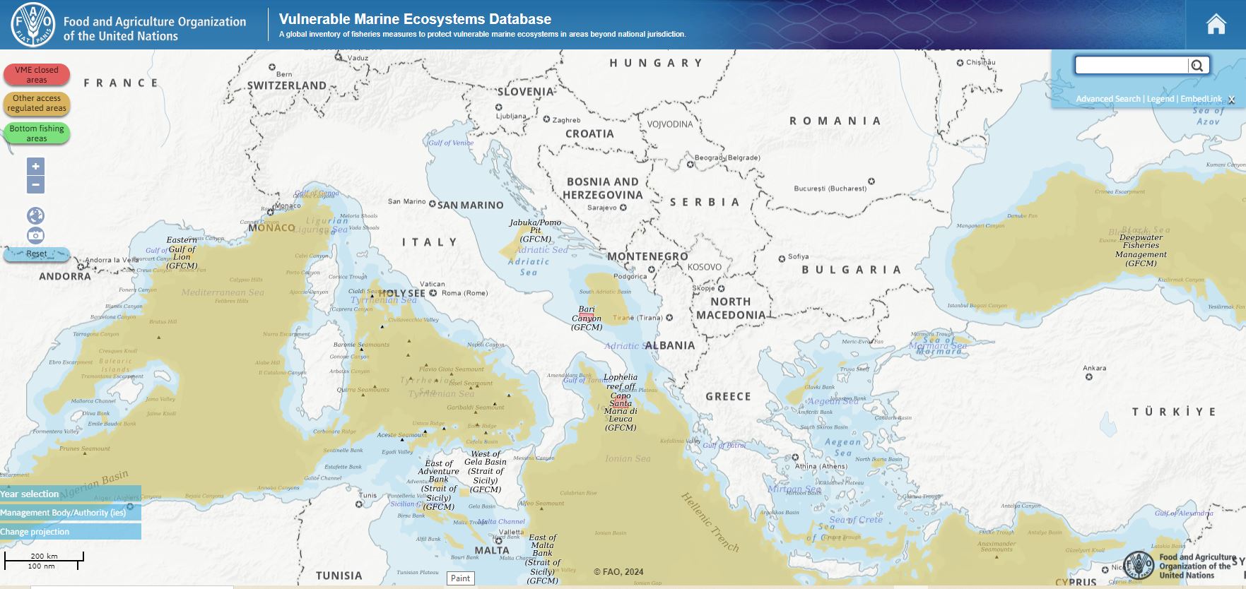
Subdataset representing the Vulnerable Marine Ecosystems Database (VME) in the Mediterranean Sea from the FAO global inventory of fisheries measures to protect vulnerable marine ecosystems in areas beyond national jurisdiction. The vulnerable marine ecosystems database was developed in collaboration with the regional bodies with mandates to manage deep-sea fisheries in areas beyond national jurisdiction (ABNJ). It is a compilation of information on management measures taken to reduce current or potential impact on areas where VMEs are known or likely to occur.
-
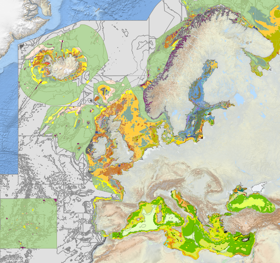
Subdataset representing the Italian seabed habitats from 2023 EUSeaMap broad-scale predictive model, produced by EMODnet Seabed Habitats.The map was produced using a "top-down" modelling approach using classified habitat descriptors to determine a final output habitat. Habitat descriptors differ per region but include: Biological zone Energy class Oxygen regime Salinity regime Seabed substrate Riverine input Habitat descriptors (excepting Substrate) are calculated using underlying physical data and thresholds derived from statistical analyses or expert judgement on known conditions. The model is produced using R and Arc Model Builder (10.1). The model was created using raster input layers with a cell size of 0.00104dd (roughly 100 metres). The model includes the sublittoral zone only; due to the high variability of the littoral zone, a lack of detailed substrate data and the resolution of the model, it is difficult to predict littoral habitats at this scale. EUSeaMap is classified into EUNIS 2019 level 3 (or more detailed levels where appropriate), EUNIS 2019 level 2 , EUNIS 2007-2011, the MSFD benthic broad habitat types, the HELCOM HUB classification in the Baltic, and the recently revised habitat classification in the Mediterranean. In the Black Sea, EUSeaMap is not classified into EUNIS 2007-2011 (due to inapplicability), but is classified according to a classification that was developed by EMODnet Seabed Habitats (Populus et a, 2017, and for a revised version Vasquez et al, 2020, See Online resources).
-
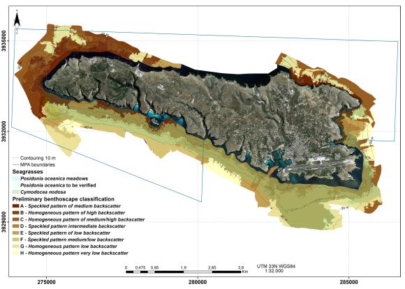
A seabed map around Lampedusa, the largest island of the Pelagie Islands Marine Protected Area (Italy, western Mediterranean). The seafloor was mapped using bathymetry and backscatter multibeam systems along with an underwater camera for direct observations and ground truthing, from the coastal area to about 50 m depth. The map was produced to monitor the present-day distribution of the Posidonia oceanica meadows around the Island. P. oceanica is the most important endemic seagrass species of the Mediterranean Sea and it can form meadows or beds extending from the surface to 40–45 m depth. These meadows provide habitat for a large community, thus increasing biodiversity of the coastal zone, stabilizing sediments and reducing coastline erosion. The seagrass meadows are susceptible to regression as response to specific impact, thus their presence and abundance can be considered an indicator of the overall environmental quality of the coastal zone. The European Union’s Habitat Directive (92/43/CEE) includes P. oceanica beds among priority habitats and, according to the Water Framework Directive (2000/60/EC), each EU Member State defined the method to evaluate the health status of the seagrass; more recently, within the Marine Strategy Framework Directive (MFSD) (2008/56/EC), P. oceanica has been selected as an indicator of the Good Environmental Status for marine areas. Consequently, the Pelagie Islands Marine Protected Area launched a project to assess the conservation status and map the distribution of P. oceanica meadows. The resulting 1:15,000 scale map includes information about the Mediterranean seagrass and the distribution of five acoustic facies reflecting hard lithologies and soft substrates. The Lampedusa seabed map provides new information which contributes to the development of a detailed benthic habitat map and a more comprehensive maritime spatial planning of this Marine Protected Area.