 CNR-ISMAR
asNeeded
Type of resources
Available actions
Topics
INSPIRE themes
Keywords
Contact for the resource
Provided by
Years
Formats
Representation types
Update frequencies
status
Scale
-
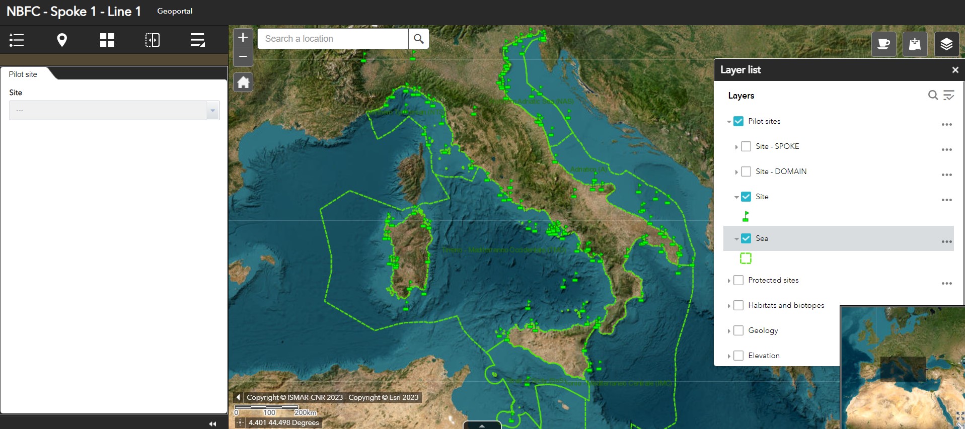
Geoportal implemented in the framework of the National (Marine) Biodiversity Observatory System of the National Biodiversity Future Center - Spoke 1 - Activity 1 - Task 1
-
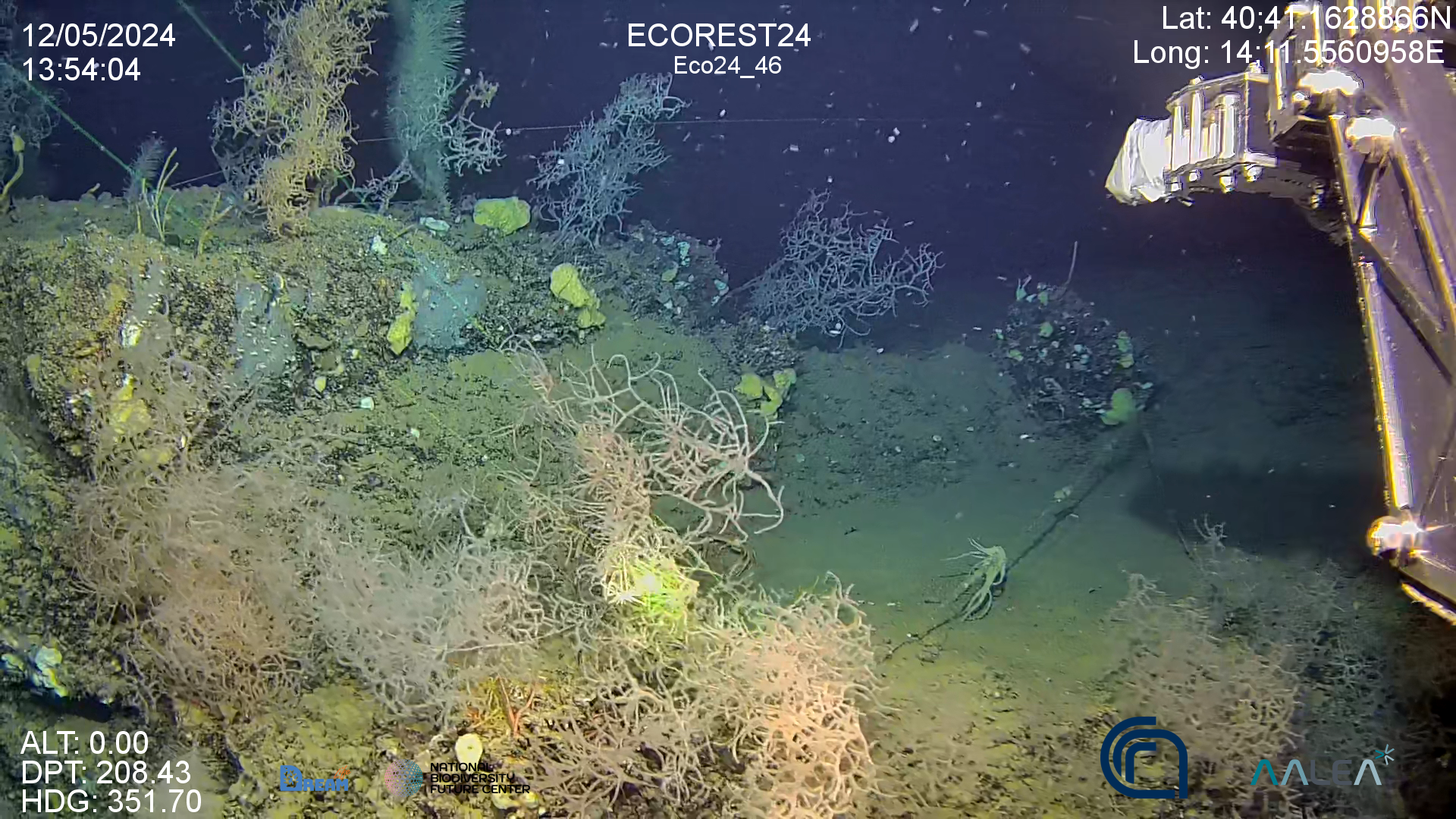
High resolution video on back corals forest in the Gulf of Naples (Italy)
-

The National Biodiversity Future Centre (NBFC) aims at harmonizing the current marine-coastal biodiversity knowledge, integrating it in databases and adopting, promoting, and making prevalent the use of the most cost/effective new/emerging monitoring methodologies and technologies. NBFC has the ambitious goal to implement a National (Marine) Biodiversity Observatory System reviewing the marine monitoring in Italy (what is done, where, and by how, how much it costs, redundancies and major gaps) and collecting data from institutional national/international programs, literature, public marine data portals, and citizen science.
-
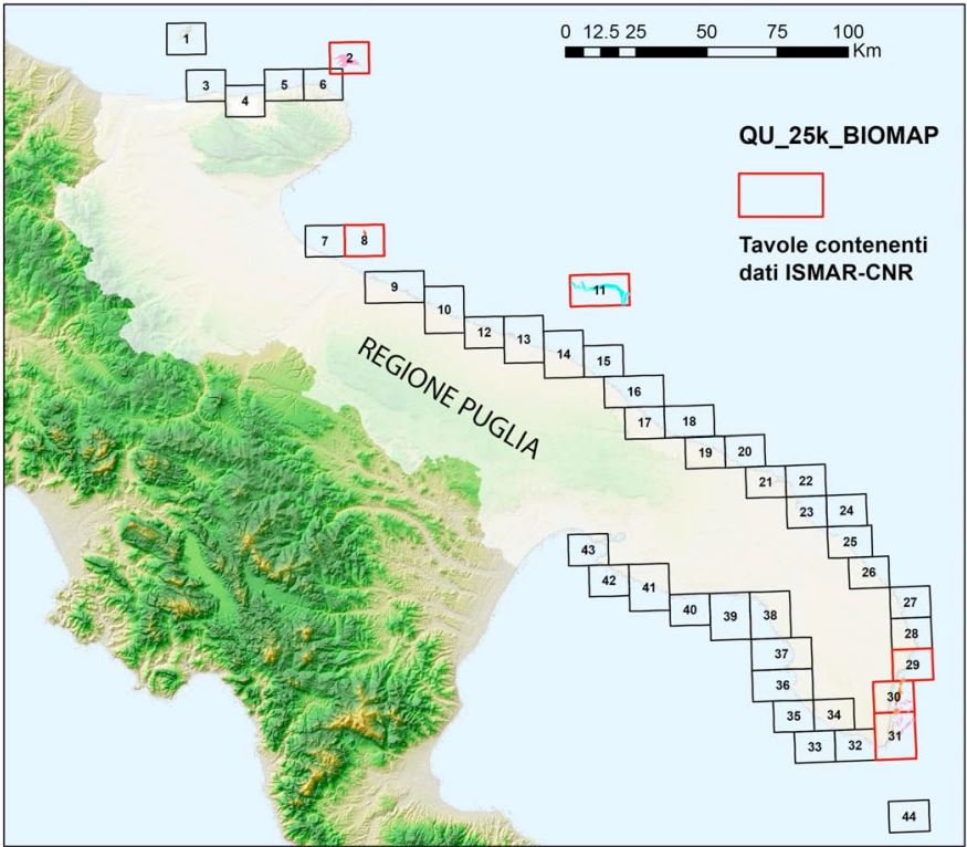
La distribuzione delle biocostruzioni lungo le coste della Puglia è conosciuta soltanto per alcuni tratti, con particolare riferimento al coralligeno, ma non è disponibile una cartografia georeferenziata aggiornata a scala regionale e, soprattutto, non è noto lo stato di conservazione delle “Scogliere” per la maggior parte della regione. In considerazione della continua crescita di pressioni antropiche, spesso interagenti, risulta altresì indispensabile l’implementazione di adeguate misure di conoscenza e di gestione finalizzate alla conservazione degli ecosistemi e dall’uso sostenibile delle risorse naturali in accordo con le Direttive Europee. In questo contesto in Puglia, nasce il progetto Biomap, che mira a dare un valido contributo alla rivisitazione dei SIC già esistenti e con la finalità di verificare e analizzare la presenza di “Scogliere” in vista della considerazione di questo habitat ai fini dell’attuazione della Direttiva sopra citata.
-

Oceanographic campaign on board the CNR R/V Gaia Blu from the 28th March to the 11th of April (LEG1) and then from the 8th May to the 14th May 2024 (LEG2), in the following monitoring sites: Santa Maria di Leuca, Monopoli continental shelf, Bari Canyon, Dauno Seamount, and Dohrn Canyon. The cruise joint the objectives of three projects, all of them intended at exploring, monitoring and restoring deep-sea habitats, the LIFE DREAM (https://www.life-dream.eu/), Spoke 1 and Spoke 2 of the PNRR NBFC (https://www.nbfc.it/en) and the HE REDRESS (https://redress-project.eu/) projects. The habitat targeted by the cruise are the cold-water corals, the deep-water oysters reefs, and the deep black coral forest, with the aim to: - restore the vulnerable marine habitats by removing the marine litter; - restore the vulnerable marine habitats by installing artificial reefs on the seafloor that provide hard substrate suitable for recruiting juvenile individuals; - monitor the vulnerable deep-sea habitats and the impacts of restoration actions by means of permanent deep observation systems; - increase knowledge and awareness on these deep-sea habitats, their ecosystem services and the importance of restoring, conserving and protecting them.
-

Oceanographic campaign on board the CNR R/V Gaia Blu from the 12th to the 22th of May 2024 in the Gulf of Naples The cruise joint the objectives of three projects, all of them intended at exploring, monitoring and restoring deep-sea habitats, the LIFE DREAM (https://www.life-dream.eu/), Spoke 1 and Spoke 2 of the PNRR NBFC (https://www.nbfc.it/en) and the HE REDRESS (https://redress-project.eu/) projects. The habitat targeted by the cruise are the cold-water corals, the deep-water oysters reefs, and the deep black coral forest, with the aim to: - restore the vulnerable marine habitats by removing the marine litter; - restore the vulnerable marine habitats by installing artificial reefs on the seafloor that provide hard substrate suitable for recruiting juvenile individuals; - monitor the vulnerable deep-sea habitats and the impacts of restoration actions by means of permanent deep observation systems; - increase knowledge and awareness on these deep-sea habitats, their ecosystem services and the importance of restoring, conserving and protecting them.
-
da compialre..
-

Catene correntometriche (mooring BB, EE, FF) equipaggiate con sensori multidisciplinari posizionati sul fondo marino e lungo la colonna d’acqua per misurare in continuo parametri fisici e bio-geochimici che consentono la comprensione e la descrizione di ecosistemi marini, il monitoraggio del cambiamento climatico e forniscono informazioni relativi a rischi naturali. Tramite di n. 2 trappole di sedimento, si ottengono misure dei flussi verticali di materiale particellato. Installate per monitorare l’arrivo stagionale dell’acqua densa (Adriatic Deep Water - AdDW; e North Adriatic dense Deep Water - NAdDW) proveniente dall’Adriatico settentrionale, e la sua variabilità interannuale e su lungo periodo per effetto dei cambiamenti climatici Sistema attivo dal 2004 e finanziato da diversi progetti scientifici (EU-EuroSTRATAFORM, EU-HERMIONE, PRIN-OBAMA, EU-Perseus, EU-CoCoNet, Progetto bandiera Ritmare (SP5-WP5-AZ3) e Strategia per l’ambiente marino (D. L. 190/2010). Inoltre questi ancoraggi oceanografici fanno parte della rete osservativa italiana di punti fissi (IFON) e, sono supportati dall’Ufficio Programmazione e Grant Office del CNR. Dal 2021 i siti BB e FF, sono entrati a far parte del consorzio EMSO-ERIC (European Multidisciplinary Seafloor and water column Observatory European-Research Infrastructure Consortium) come nodo osservativo del mare Adriatico meridionale composto dagli ancoraggi BB e FF e dal sito osservativo E2M3A gestito da OGS Trieste. La partecipazione ad EMSO-ERIC è sostenuta anche dalle attività della Joint Research Unit Italiana del consorzio (EMSO Italia). Infine il mooring BB è parte della Rete di Misurazioni in continuo a lungo termine della temperatura e salinità delle acque profonde del Mediterraneo (Programma Hydrochanges della CIESM). Gli strumenti impiegati sono dotati di memoria ed alimentazione interna. I dati oceanografici sono scaricati in modalità delayed durante la manutenzione degli ancoraggi che avviene con cadenza semestrale o annuale. Durante la manutenzione gli ancoraggi vengono recuperati per eseguire lo scarico dei dati, la raccolta dei campioni delle trappole, la sostituzione delle batterie e la verifica della funzionalità prima della rimessa a mare. Queste manutenzioni sono state eseguite utilizzando diverse navi da ricerca del CNR (R/V Urania, R/V Minerva Uno e N/O G. Dallaporta) o navi di opportunità nell’ambito delle attività sperimentali dei progetti sopracitati. Personale coinvolto: Stefano Miserocchi (stefano.miserocchi AT cnr.it), Leonardo Langone e Patrizia Giordano."
-
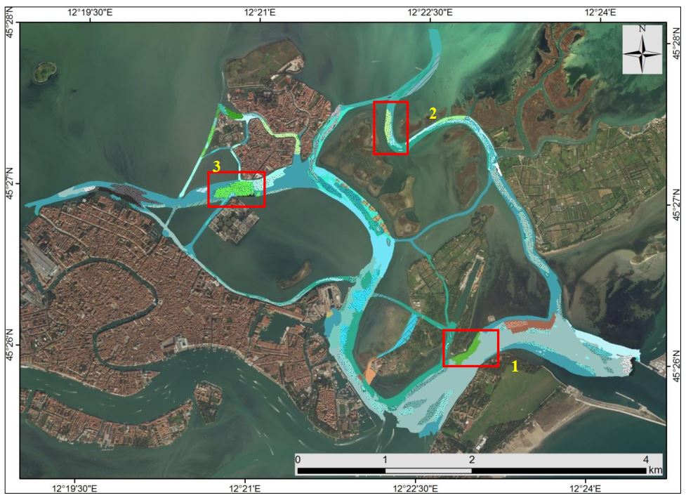
Benthic habitat map of the San Felice channel in the Venice Lagoon from the thesis "Mappatura degli habitat bentonici dell'area nord-est di Venezia, con particolare attenzione alla componente macroalgale" by Elena Catenacci (Alma Mater Studiorum Università di Bologna)
-
L’obiettivo è valutare la presenza di microplastiche nei tre sottobacini lagunari e nel bacino scolante per comprendere i percorsi di trasporto di questi inquinanti. In particolare ISP si occupa di quantificare e caratterizzare simultaneamente le small microplastics (<100 µm), additivi plastici e altre componenti del microlitter in acque e sedimenti. Campionate acque in 12 siti lagunari per 4 campagne nel periodo 2022-2023 nei tre sottobacini, in quattro di questi siti sono anche stati campionati i sedimenti in una sola campagna. Nel bacino scolante sono stati campionati 11 siti per 4 campagne di campionamento nel 2022-2023. Inoltre è stato campionato per 12 mesi consecutivi il sito CUAI (Canale Unico Acque Irrigue) che raccoglie le acque dal Sile e le porta al potabilizzatore di Ca’ Solaro