 CNR-ISMAR
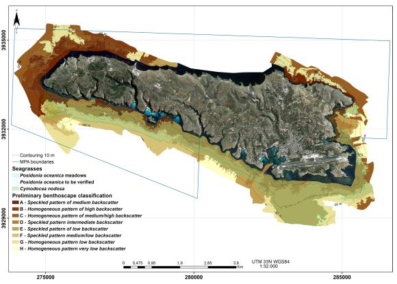
Distribution of Posidonia oceanica (L.) Delile around Lampedusa Island (Strait of Sicily, Italy)
A seabed map around Lampedusa, the largest island of the Pelagie Islands Marine Protected Area (Italy, western Mediterranean). The seafloor was mapped using bathymetry and backscatter multibeam systems along with an underwater camera for direct observations and ground truthing, from the coastal area to about 50 m depth. The map was produced to monitor the present-day distribution of the Posidonia oceanica meadows around the Island. P. oceanica is the most important endemic seagrass species of the Mediterranean Sea and it can form meadows or beds extending from the surface to 40–45 m depth. These meadows provide habitat for a large community, thus increasing biodiversity of the coastal zone, stabilizing sediments and reducing coastline erosion. The seagrass meadows are susceptible to regression as response to specific impact, thus their presence and abundance can be considered an indicator of the overall environmental quality of the coastal zone. The European Union’s Habitat Directive (92/43/CEE)
includes P. oceanica beds among priority habitats and, according to the Water Framework Directive (2000/60/EC), each EU Member State defined the method to evaluate the health status of the seagrass; more recently, within the Marine Strategy Framework Directive (MFSD) (2008/56/EC), P. oceanica has been selected as an indicator of the Good Environmental Status for marine areas. Consequently, the Pelagie Islands Marine Protected Area launched a project to assess the conservation status and map the distribution of P. oceanica meadows. The resulting 1:15,000 scale map includes information about the Mediterranean seagrass and the distribution of five acoustic facies reflecting hard lithologies and soft substrates. The Lampedusa seabed map provides new information which contributes to the development of a detailed benthic habitat map and a more comprehensive maritime spatial planning of this Marine Protected Area.
Base
- Data (Pubblicazione)
- 2016-06-20
- Identificatore
-
http://dx.doi.org/10.1080/17445647.2016.1195298
- Data (Pubblicazione)
- 2016-06-20
- Altri dettagli
- How to cite this data: Renato Tonielli, Sara Innangi, Francesca Budillon, Gabriella Di Martino, Marcello Felsani, Fabio Giardina, Michele Innangi & Francesco Filiciotto (2016): Distribution of Posidonia oceanica (L.) Delile meadows around Lampedusa Island (Strait of Sicily, Italy), Journal of Maps, DOI: 10.1080/17445647.2016.1195298
- Identificatore
-
http://libeccio.bo.ismar.cnr.it:8080/geonetwork/srv/eng/catalog.search#/metadata/f80fb8f8-e9db-45f3-b0e1-d05bc76efdda
- Data (Pubblicazione)
- 2024-11-18
- Crediti
- © CNR-ISMAR
- Status
- In corso
- Frequenza di aggiornamento
- Secondo necessità
- Parole chiave
-
- seafloor sedimentological map
- posidonia oceanica distribution
- lampedusa island
- pelagian islands
- nbfc
- GEMET - INSPIRE themes, version 1.0
-
- Habitats and biotopes
- Geology
- Limitazione d’uso
- None
- Vincoli di fruibilità
- Licenza
- Altri vincoli
- CC BY-NC-SA
- Vincoli di accesso
- Licenza
- Altri vincoli
- CC BY-NC-SA
- Classificazione
- Non riservato
- Identificatore aggregato del dataset
- bbc5cc58-5239-429c-ad4c-b59bda1993d5
- Tipo di associazione
- Parte del database senza soluzione di continuità
- Tipo di iniziativa
- Studio
- Tipo di rappresentazione spaziale
- Dati vettoriali
- Lingua dei metadati
- English
- Set dei caratteri dei metadati
- UTF8
- Tema
-
- Informazioni geoscientifiche
- Descrizione
- Italy
))
- Informazioni supplementari
- Lampedusa Island, Pelagian Islands, Strait of Sicily, Italy
- Identificatore del sistema di riferimento
- EPSG / 32633
informazioni sulla rappresentazione spaziale
- Livello di topologia
- Solo Geometria
- Oggetto di tipo geometrico
- Superficie
- Conteggio oggetto geometrico
- 22
- Formato di distribuzione
-
-
Shapefile
(
.shp
)
-
Shapefile
(
.shp
)
- Risorsa online
-
Scientific paper
(
DOI
)
Innangi et al., 2018
- Risorsa online
-
Scientific paper
(
DOI
)
Tonielli et al., 2016
- Livello
- Dataset
- Dataset
- Dataset
Conformità
- Data (Pubblicazione)
- 2020-10-09
- Spiegazione
- Validated in Geonetwork according to the ISO19115 rules (25/25) and the INSPIRE rules (30/30)
- Pass
- Yes
- Genealogia del dato – Processo di produzione
-
Bathymetry data: The Digital Terrain Model (2.5 m x cell) was carried out with integration of the data
acquired in 2006 with multibeam Reson SeaBat 8125 and of the data acquired in 2015 with multibeam
Reson SeaBat 7125.
Backscatter data: the acoustic mosaic (20 cm x pixel) was carried out with the processing of Sidesca-like
data of the multibeam Reson SeaBat 7125.
Video image: The frames of video image was carried out with the logging of the underwater camera GOProHero 3.
Satellite image: The satellite image was saved from the Italian National Data Portal (http://www.pcn.minambiente.it/GN/).
- Identificatore del file di metadati
- f80fb8f8-e9db-45f3-b0e1-d05bc76efdda XML
- Lingua dei metadati
- English
- Set dei caratteri dei metadati
- UTF8
- Identificatore metadati di rango superiore
- Backscatter Lampedusa 2015 d6fe640d-dfc0-4868-8463-a60a827892d6
- Livello gerarchico
- Dataset
- Data dei metadati
- 2024-11-11T13:47:50
- Nome dello Standard dei metadati
- ISO 19115:2003/19139
- Versione dello Standard dei metadati
- 1.0