 CNR-ISMAR
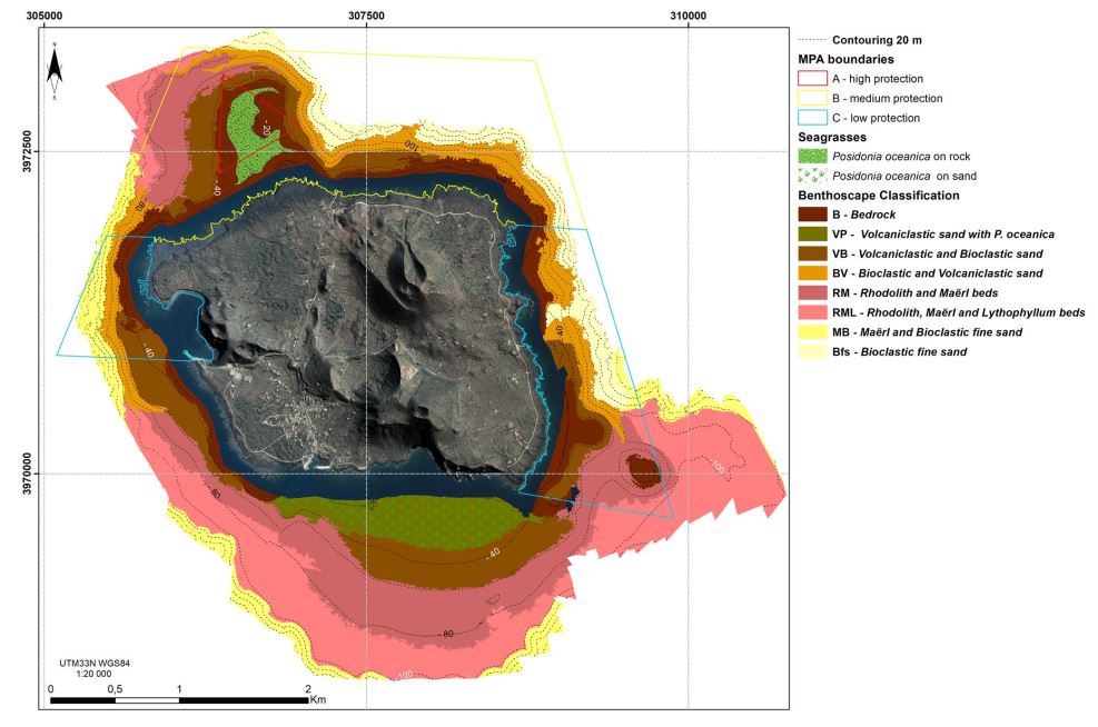
Benthoscape classifcation of Linosa Island
Base
- Data (Pubblicazione)
- 2018-10-13
- Identificatore
-
https://doi.org/10.1007/s11001-018-9371-6
- Data (Pubblicazione)
- 2018-10-13
- Altri dettagli
- How to cite this data: Innangi, S., Tonielli, R., Romagnoli, C. et al. Seabed mapping in the Pelagie Islands marine protected area (Sicily Channel, southern Mediterranean) using Remote Sensing Object Based Image Analysis (RSOBIA). Mar Geophys Res 40, 333–355 (2019). https://doi.org/10.1007/s11001-018-9371-6
- Identificatore
-
http://libeccio.bo.ismar.cnr.it:8080/geonetwork/srv/eng/catalog.search#/metadata/bbc5cc58-5239-429c-ad4c-b59bda1993d5
- Data (Pubblicazione)
- 2024-11-18
- Crediti
- © CNR-ISMAR
- Status
- In corso
- Frequenza di aggiornamento
- Secondo necessità
- Parole chiave
-
- benthoscape
- habitats
- linosa island
- pelagian islands
- nbfc
- GEMET - INSPIRE themes, version 1.0
-
- Habitats and biotopes
- Geology
- Limitazione d’uso
- None
- Vincoli di fruibilità
- Licenza
- Altri vincoli
- CC BY-NC-SA
- Vincoli di accesso
- Licenza
- Altri vincoli
- CC BY-NC-SA
- Classificazione
- Non riservato
- Tipo di rappresentazione spaziale
- Dati vettoriali
- Lingua dei metadati
- English
- Set dei caratteri dei metadati
- UTF8
- Tema
-
- Informazioni geoscientifiche
- Descrizione
- Italy
))
- Informazioni supplementari
- Linosa Island, Pelagian Islands, Strait of Sicily, Italy
- Identificatore del sistema di riferimento
- EPSG / 32633
informazioni sulla rappresentazione spaziale
- Livello di topologia
- Solo Geometria
- Oggetto di tipo geometrico
- Superficie
- Conteggio oggetto geometrico
- 10
- Formato di distribuzione
-
-
Shapefile
(
.shp
)
-
Shapefile
(
.shp
)
- Risorsa online
-
Scientific paper
(
DOI
)
Innangi et al., 2018
- Livello
- Dataset
- Dataset
- Dataset
Conformità
- Data (Pubblicazione)
- 2020-10-09
- Spiegazione
- Validated in Geonetwork according to the ISO19115 rules (25/25) and the INSPIRE rules (30/30)
- Pass
- Yes
- Genealogia del dato – Processo di produzione
-
Seabed maps of the shallow-water areas of Lampedusa and Linosa, belonging to the Pelagie Islands Marine Protected Area. Two surveys were carried out (“Lampedusa 2015” and “Linosa 2016”) to collect bathymetric and acoustic backscatter data through the use of a Reson SeaBat 7125 high-resolution multibeam system. Ground-truth data,
in the form of grab samples and diver video-observations, were also collected during both surveys. Sediment samples were analyzed for grain size, while video images were analyzed and described revealing the acoustic seabed and other bio-physical characteristics. A map of seabed classifcation, including sediment types and seagrass distribution, was produced using the tool Remote Sensing Object Based Image Analysis (RSOBIA) by integrating information derived from backscatter data and bathy-morphological features, validated by ground-truth data. This allows to create a frst seabed maps (i.e. benthoscape classifcation), of Lampedusa and Linosa, at scale 1:20 000 and 1:32 000, respectively, that will be checked and implemented through further surveys. The results point out a very rich and largely variable marine ecosystem on the seabed surrounding the two islands, with the occurrence of priority habitats, and will be of support for a more comprehensive maritime spatial planning of the Marine Protected Area
- Identificatore del file di metadati
- bbc5cc58-5239-429c-ad4c-b59bda1993d5 XML
- Lingua dei metadati
- English
- Set dei caratteri dei metadati
- UTF8
- Identificatore metadati di rango superiore
- Backscatter Linosa 2016 071f3fa5-414b-4fe4-9adc-7d6389da679f
- Livello gerarchico
- Dataset
- Data dei metadati
- 2024-11-11T13:48:17
- Nome dello Standard dei metadati
- ISO 19115:2003/19139
- Versione dello Standard dei metadati
- 1.0