 CNR-ISMAR
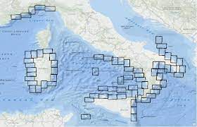
Index map - Project MAGIC
Index map of the 72 cartographic sheets produced within the Project MArine Geohazards along the Italian Coasts carried out by the Italian research groups actively working on Marine Geology with also the contribution of the University of Nice. Original metadata sheet:
http://dati.protezionecivile.it/geoportalDPC/catalog/search/resource/details.page?uuid=PCM_MaGIC1_01%3A20160704%3A081100
Simple
- Date (Creation)
- 2022-07-21
- Credit
- Civil Protection Department (Italian Government)
- Status
- Completed
Resource provider
National Research Council - Istitute of Marine Sciences (CNR-ISMAR)
-
Mariacristina Prampolini
(
Post doc
)
https://orcid.org/0000-0002-0408-4411
- Maintenance and update frequency
- As needed
- Keywords
-
- Marine geology
- Continental shelf
- nbfc
- GEMET - INSPIRE themes, version 1.0
-
- Sea regions
- Natural risk zones
- Use limitation
- None
- Use constraints
- Other restrictions
- Other constraints
- https://creativecommons.org/licenses/by/4.0/
- Access constraints
- Other restrictions
- Other constraints
- https://creativecommons.org/licenses/by/4.0/
- Classification
- Unclassified
- Aggregate Datasetindentifier
- 5e30554a-7c5b-40d3-a2bf-199ea5a8cd32
- Association Type
- Part of seamless database
- Spatial representation type
- Vector
- Denominator
- 50000
- Metadata language
- Italiano
- Character set
- UTF8
- Description
- Italian seas
N
S
E
W
))
- Supplemental Information
- None
- Reference system identifier
- EPSG / EPSG:4326 - World Geodetic System 1984
Spatial representation info
No information provided.
- Topology level
- Geometry only
- Geometric object type
- Surface
- Geometric object count
- 1
- Distribution format
-
-
Shapefile
(
x
)
-
Shapefile
(
x
)
- Hierarchy level
- Dataset
- Dataset
- Dataset
Conformance result
- Date (Publication)
- 2020-10-09
- Explanation
- Validated in Geonetwork according to the ISO19115 rules (25/25) and the INSPIRE rules (30/30)
- Pass
- Yes
- Statement
- This dataset was produced within the Project MAGIC and was downloaded aat the following link https://github.com/pcm-dpc/MaGIC on the 22/07/2022. More details available at http://dati.protezionecivile.it/geoportalDPC/catalog/search/resource/details.page?uuid=PCM_MaGIC1_01%3A20160704%3A081100
- File identifier
- b5eeb300-7a1a-44ae-8aab-d2f604e93798 XML
- Metadata language
- English
- Character set
- UTF8
- Parent identifier
- MAGIC Project - MArine Geohazard along the Italian Coast 31cbb959-c331-49f0-b086-0c64aa707dee
- Hierarchy level
- Dataset
- Date stamp
- 2023-12-06T09:52:28
- Metadata standard name
- ISO 19115:2003/19139
- Metadata standard version
- 1.0
Overviews
Spatial extent
N
S
E
W
Provided by

Associated resources
Not available