 CNR-ISMAR
Bathymetry Linosa 2016
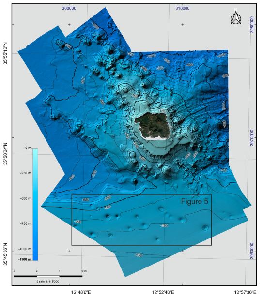
Bathymetry of Linosa Island (10 × 10 m cell grid size) collected by the Institute for Coastal Marine Environment (IAMC, now ISMAR, Institute of Marine Sciences) of the National Research Council (CNR) of Naples (Italy) during two oceanographic surveys, ‘Linosa 2016’ (17–29 August 2016) and ‘BioGeoLin 2017’ (8–20 September 2017), onboard the R/V Minerva UNO
Base
- Data (Creazione)
- 2016
- Data (Pubblicazione)
- 2019
- Identificatore
-
https://doi.org/10.1080/17445647.2019.1642807
- Data (Pubblicazione)
- 2019-08-08
- Altri dettagli
- How to cite this data: Renato Tonielli, Sara Innangi, Gabriella Di Martino & Claudia Romagnoli (2019) New bathymetry of the Linosa volcanic complex from multibeam systems (Sicily Channel, Mediterranean Sea), Journal of Maps, 15:2, 611-618
- Identificatore
-
http://libeccio.bo.ismar.cnr.it:8080/geonetwork/srv/eng/catalog.search#/metadata/aa6942e6-42c3-425c-8e20-d3ddac60caf8
- Data (Pubblicazione)
- 2024-11-18
- Crediti
- © CNR-ISMAR
- Status
- Completato
Fornitore della risorsa
National Research Council (CNR) - Institute of Marine Science (ISMAR)
-
Sara Innangi
(
Researcher
)
Calata Porta Di Massa Porto Di Napoli, 80
,
Naples
,
80133
,
Italy
https://orcid.org/0000-0002-7692-9356
Fornitore della risorsa
National Research Council (CNR) - Institute of Marine Science (ISMAR)
-
Gabriella di Martino
(
Technologist
)
Calata Porta Di Massa Porto Di Napoli, 80
,
Naples
,
80133
,
Italy
https://orcid.org/0000-0001-6630-3432
Ricercatore principale
National Research Council (CNR) - Institute of Marine Science (ISMAR)
-
Renato Tonielli
(
Technologist
)
Calata Porta Di Massa Porto Di Napoli, 80
,
Naples
,
80133
,
Italy
- Frequenza di aggiornamento
- Secondo necessità
- GEMET - INSPIRE themes, version 1.0
-
- Geology
- Continents, countries, sea regions of the world.
-
- Italy
- Strait of Sicily
- Mediterranean Sea
- Platform Type
-
- research vessel
- Survey type
-
- Geophysics
- Cartography
- Collection method
-
- Sonar system
- Device
-
- Multibeam
- Swath type
-
- Bathymetry
- Parole chiave
-
- linosa island
- pelagie islands
- nbfc
- Limitazione d’uso
- Do not use for navigation
- Vincoli di fruibilità
- Licenza
- Altri vincoli
- CC BY NC 4.0
- Vincoli di accesso
- Licenza
- Altri vincoli
- CC BY NC 4.0
- Classificazione
- Non riservato
- Identificatore aggregato del dataset
- 071f3fa5-414b-4fe4-9adc-7d6389da679f
- Tipo di associazione
- Parte del database senza soluzione di continuità
- Tipo di iniziativa
- Campagna
- Tipo di rappresentazione spaziale
- Dati raster
- Lingua dei metadati
- English
- Set dei caratteri dei metadati
- UTF8
- Tema
-
- Quote e prodotti derivati
- Informazioni geoscientifiche
Estensione

Estensione
- Informazioni supplementari
- none
- Identificatore del sistema di riferimento
- EPSG:32633 - WGS 84 / UTM zone 33N
- Livello di topologia
- Solo Geometria
- Oggetto di tipo geometrico
- Superficie
- Conteggio oggetto geometrico
- 1
- Formato di distribuzione
-
-
GeoTIFF
(
.tif
)
-
GeoTIFF
(
.tif
)
Distributore
National Research Council (CNR) - Institute of Marine Science (ISMAR)
http://www.ismar.cnr.it/
- Risorsa online
-
Scientific paper
(
DOI
)
Tonielli et al, 2019
- Livello
- Modello
- Dataset
- Bathymetric surface
Conformità
- Data (Pubblicazione)
- 2023-07-01
- Spiegazione
- Validated in Geonetwork according to the ISO19115 rules (25/25) and the INSPIRE rules (30/30)
- Pass
- Yes
- Genealogia del dato – Processo di produzione
- Geophysical data were collected by the Institute for Coastal Marine Environment (IAMC, now ISMAR, Institute of Marine Sciences) of the National Research Council (CNR) of Naples (Italy) during two oceano graphic surveys, ‘Linosa 2016’ (17–29 August 2016) and ‘BioGeoLin 2017’ (8–20 September 2017), onboard the R/V Minerva UNO (Di Martino et al., 2017; Innangi & Tonielli, 2017). Multibeam bathymetric surveys were carried out around Linosa Island from about 15 to 1000 m of depth, obtaining the almost whole coverage of its submarine flanks down to the base of the volcanic edifice and in surrounding areas. The shallow-water survey was performed from 15 to about 180 m of depth using a Teledyne Reson SeaBat 7125 while the seabed down to 1000 m of depth was investigated using a Teledyne Reson SeaBat 7160. Bathymetric data were collected and processed using Teledyne PDS 4.1; the software received positioning information from an Oministar Differential Global Positioning System (DGPS) and attitude data from an Ixea Octans 3000 motion sensor. Sound velocity values at multibeam transducers were provided by a Valeport mini-SVS probe, while a sound velocity profiler was systematically used to get the velocity profile in the water column. Both measurements are required for a proper depth computation. During the surveys various filter settings were applied to the multibeam data and quality control displays were used to check the data quality; data logging progress was shown in real-time using a color-coded Digital Terrain Model (DTM). The PDS Editing combines in a single module 3D swath editing, multibeam calibration, DTM editing and SVP editor and it allows to clean swath data and to update DTM model in real-time. Data de-spiking was carried out manually without the application of automatic filters in order to preserve data accuracy and resolution. Bathymetric data, previously collected in very shallow-water in the framework of a mapping project, were also available (Coastal Consulting Exploration s.r.l., 2008). This latter dataset was acquired in 2008 using Reson SeaBat 8125 and was integrated with the new data in order to expand the bathymetric map towards the coast (less than 15 m of the depth). These data were acquired only within the Pelagie Marine Protected Area (Innangi et al., 2018; Tonielli, Di Martino, & Innangi, 2017). Therefore, in the southern sector, which is not included in the MPA, the bathymetric data are missing in the range from 20 m to the coast.
- Identificatore del file di metadati
- aa6942e6-42c3-425c-8e20-d3ddac60caf8 XML
- Lingua dei metadati
- English
- Set dei caratteri dei metadati
- UTF8
- Livello gerarchico
- Modello
- Nome del livello gerarchico
- Bathymetric surface
- Data dei metadati
- 2024-11-28T13:58:11
- Nome dello Standard dei metadati
- ISO 19115:2003/19139
- Versione dello Standard dei metadati
- 1.0