 CNR-ISMAR
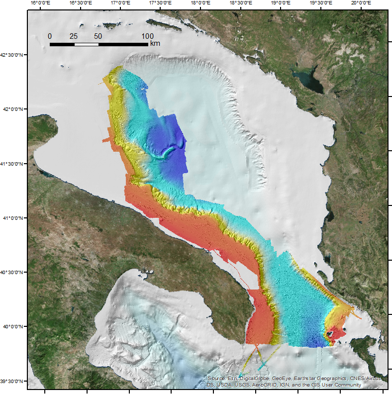
SOUTH ADRIATIC DTM 20 m
This DTM is the result of merging of several multibeam surveys identified by their CDIs names and short dataset names: 145_CNR-ISMAR-06,
STRATA05;145_CNR-ISMAR-07,SETE06;145_CNR-ISMAR-08,BARCA07;145_CNR-ISMAR-09,SASSI08;145_CNR-ISMAR-10,IMPACT09;145_
CNR-ISMAR-11,MAGIC0409;145_CNR-ISMAR-12,ARCADIA;145_CNR-ISMAR-13,ARCO;145_145_CNR-ISMAR-44,RISA09;145_145_CNR-ISMAR-45,
SOM09;145_145_CNR-ISMAR-46,MAGIC0709-ADRIA;145_145_CNR-ISMAR-47,MAGIC0910;145_145_CNR-ISMAR-48,MAGIC0211;145_145_
CNR-ISMAR-49,OBAMA;145_145_CNR-ISMAR-52,MEMA12;145_145_CNR-ISMAR-62,COCOMAP13;145_145_CNR-ISMAR-74,COCOMAP14.
Base
- Data (Creazione)
- 2017-09-30T00:00:00
- Data (Revisione)
- 2018-02-02
- Identificatore
- DTM_CNR-ISMAR-122
- Crediti
- © CNR-ISMAR
(+39) 051 639 8939
http://www.bo.ismar.cnr.it/
(+39) 051 639 8939
http://www.bo.ismar.cnr.it/
- Parameter Discovery Vocabulary (P02)
-
- Bathymetry and Elevation
- SeaDataNet device categories
-
- multi-beam echosounders
- Positioning devices
-
- Differential Global Positioning System receivers
- Vertical Datum
-
- sea level
- Project name
-
- EMODnet HRSM
- Thèmes Sextant
-
- /Physical Environment/Bathymetry/Digital Terrain Model
- Vincoli di accesso
- Licenza
- Vincoli di fruibilità
- Licenza
- Altri vincoli
- CC BY NC
- Limitazione d’uso
- Not to be used for navigation
- Tipo di rappresentazione spaziale
- Dati raster
- Denominatore
- 5000
- Distanza
- 20 meter
- Lingua dei metadati
- English
- Set dei caratteri dei metadati
- UTF8
- Tema
-
- Acque marine
- Data di inizio
- 2005
- Data di fine
- 2014 after
Estensione verticale
- Quota minima
- 8.5
- Quota massima
- 1234
- Descrizione
- South Adriatic Sea
))
- Identificatore del sistema di riferimento
- EPSG / WGS 84 (EPSG:4326) / 7.4
- Numero delle dimensioni
- 3
- Nome dimensione
- Colonna
- Misura dimensione
- 2967
- Nome dimensione
- Riga
- Misura dimensione
- 2790
- Nome dimensione
- Tempo
- Misura dimensione
- 1
- Risoluzione
- 1 second
- Geometria della cella
- Punto
- Disponibilità dei coefficienti della trasformazione
- No
- Disponibilità dei checkpoint
- No
- Punto del pixel
-
- Centro
- Formato di distribuzione
-
-
XYZ Ascii
(
)
-
XYZ Ascii
(
)
- Dimensioni di trasferimento
- 309
- Risorsa online
-
Scientific paper
(
WWW:LINK-1.0-http--link
)
Fabio Trincardi, Elisabetta Campiani, Annamaria Correggiari, Federica Foglini, Vittorio Maselli & Alessandro Remia (2014) Bathymetry of the Adriatic Sea: The legacy of the last eustatic cycle and the impact of modern sediment dispersal, Journal of Maps, 10:1, 151-158, DOI: 10.1080/17445647.2013.864844
- Livello
- Dataset
Conformità
- Data
- Pass
- No
Accuratezza di attributo quantitativo
- Nome di misura
- depth
- Misura di identificazione
- depth accuracy
- Descrizione dell misura
- Different Multibeam Systems: 100 kHz Kongsberg EM710, 30kHz Kongsberg EM302, 100 kHz Reson Seabat 8160, 300 kHz Kongsberg EM3002D
Misure di qualità dei dati
- Valore
- not defined
Accuratezza posizionale di dati griglia
- Nome di misura
- horizontal accuracy
- Misura di identificazione
- horizontal accuracy of coordinate
- Descrizione dell misura
- DGPS system
Misure di qualità dei dati
- Tipo di valore
- horizontal accuracy
Accuratezza posizionale dei dati
- Nome di misura
- emodnet-bathymetry.QI.Horizontal
- Valore
- 3 - < 20 m
Accuratezza posizionale dei dati
- Nome di misura
- emodnet-bathymetry.QI.Vertical
- Valore
- 2 - MBES low frequency (lower than 100kHz) (similar than 1+2%d)
Consistenza di dominio
- Nome di misura
- emodnet-bathymetry.QI.Purpose
- Valore
- 2 - Bathymetric/morphologic survey
- Livello
- Software
- Altro
- software
- Livello
- Tipo di proprietà
- Descrizione
- parameters of data processing
- Genealogia del dato – Processo di produzione
- The multibeam datasets have been processed and merged using the software CARIS HIPS & SIPS at a resolution of 20 m.
- Descrizione
-
The data sources belong to several multibeam surveys undertaken in the South Adriatic Sea (western Adriatic continental margin) from 2005 to
2014. For the specific description of the single surveys, please refer to the Seadatanet catalogue for the partner CNR-ISMAR, Edmo number 145 (
see above CDIs names).
- Identificatore del file di metadati
- SDN_CPRD_145_DTM_CNR-ISMAR-122 XML
- Lingua dei metadati
- English
- Set dei caratteri dei metadati
- UTF8
- Nome del livello gerarchico
- Composite Product Record
- Data dei metadati
- 2024-11-25T14:01:19
- Nome dello Standard dei metadati
- ISO 19115:2003/19139 - EMODNET - BATHYMETRY
- Versione dello Standard dei metadati
- 1.0
(+39) 051 639 8939
http://www.bo.ismar.cnr.it/