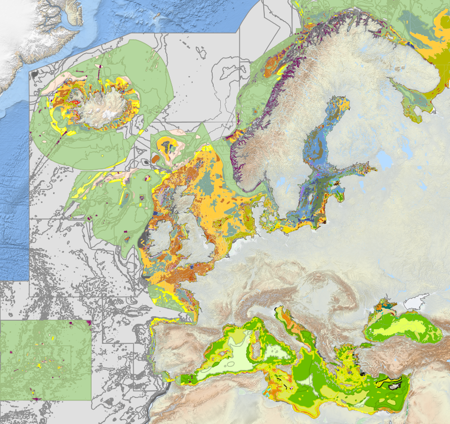
EUSeaMap 2023 Broad-Scale Predictive Habitat Map for Europe (EMODnet)
Subdataset representing the Italian seabed habitats from 2023 EUSeaMap broad-scale predictive model, produced by EMODnet Seabed Habitats.The map was produced using a "top-down" modelling approach using classified habitat descriptors to determine a final output habitat. Habitat descriptors differ per region but include: Biological zone Energy class Oxygen regime Salinity regime Seabed substrate Riverine input Habitat descriptors (excepting Substrate) are calculated using underlying physical data and thresholds derived from statistical analyses or expert judgement on known conditions. The model is produced using R and Arc Model Builder (10.1). The model was created using raster input layers with a cell size of 0.00104dd (roughly 100 metres). The model includes the sublittoral zone only; due to the high variability of the littoral zone, a lack of detailed substrate data and the resolution of the model, it is difficult to predict littoral habitats at this scale. EUSeaMap is classified into EUNIS 2019 level 3 (or more detailed levels where appropriate), EUNIS 2019 level 2 , EUNIS 2007-2011, the MSFD benthic broad habitat types, the HELCOM HUB classification in the Baltic, and the recently revised habitat classification in the Mediterranean. In the Black Sea, EUSeaMap is not classified into EUNIS 2007-2011 (due to inapplicability), but is classified according to a classification that was developed by EMODnet Seabed Habitats (Populus et a, 2017, and for a revised version Vasquez et al, 2020, See Online resources).
Base
- Data (Pubblicazione)
- 2024-01-10
- Identificatore
- 0a1cb988-22de-48b2-8cda-d90947ef77d1
- Crediti
- Licensed under CC-BY 4.0 from the European Marine Observation and Data Network (EMODnet) Seabed Habitats initiative (www.emodnet-seabedhabitats.eu), funded by the European Commission
- Status
- Completato
Fornitore della risorsa
National Research Council (CNR) - Institute of Marine Science (ISMAR)
-
Valentina Grande
(
Catalogue manager
)
Bologna
,
40129
,
https://orcid.org/0000-0002-3489-268X
- Frequenza di aggiornamento
- Secondo necessità
- Parole chiave
-
- seabed habitat
- emodnet
- italian waters
- nbfc
- substrate
- biozone
- benthic map
- GEMET - INSPIRE themes, version 1.0
-
- Habitats and biotopes
- Limitazione d’uso
- None
- Vincoli di fruibilità
- Licenza
- Altri vincoli
- CC-BY 4.0
- Vincoli di accesso
- Licenza
- Altri vincoli
- CC-BY 4.0
- Classificazione
- Non riservato
- Tipo di rappresentazione spaziale
- Dati vettoriali
- Lingua dei metadati
- English
- Set dei caratteri dei metadati
- UTF8
- Tema
-
- Biologia
N
S
E
W
))
- Informazioni supplementari
- Italian waters
- Identificatore del sistema di riferimento
- EPSG / EPSG:3857
informazioni sulla rappresentazione spaziale
No information provided.
- Livello di topologia
- Solo Geometria
- Oggetto di tipo geometrico
- Punto
- Conteggio oggetto geometrico
- 4
- Formato di distribuzione
-
-
Shapefile
(
.shp
)
-
Shapefile
(
.shp
)
Distributore
National Research Council - Institute of Marine Science (CNR-ISMAR))
-
Director
(
Director
)
- Risorsa online
-
Source
(
WWW:LINK-1.0-http--link
)
Metadata
- Livello
- Dataset
- Dataset
- Dataset
Conformità
- Data (Pubblicazione)
- 2020-10-09
- Spiegazione
- Validated in Geonetwork according to the ISO19115 rules (25/25) and the INSPIRE rules (30/30)
- Pass
- Yes
- Genealogia del dato – Processo di produzione
- Downloaded from https://files.emodnet-seabedhabitats.eu/data/EUSeaMap_2023.zip and modified by CNR-ISMAR in the framework of the NBFC.
- Identificatore del file di metadati
- 115e1ddb-0fc5-4b09-a437-ba64f5d0eaff XML
- Lingua dei metadati
- English
- Set dei caratteri dei metadati
- UTF8
- Livello gerarchico
- Dataset
- Data dei metadati
- 2024-01-15T11:18:31
- Nome dello Standard dei metadati
- ISO 19115:2003/19139
- Versione dello Standard dei metadati
- 1.0
 CNR-ISMAR

