CNR-ISMAR
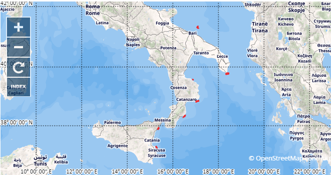
MSFD15 bathymetry
Batimetria MSFD15
The data have been acquired with a Reson 7060 multi beam echosounder hull-mounted on board the R/V Minerva in the framework of the monitoring activities of the Marine Strategy Framework Directive (MSFD). The aim of the survey was to map the submerged landscape for monitoring benthic habitats (Cold Water corals, Coralligenus, Maerl and Posidonia) following the MSFD protocols in the assessment areas.
nessuno
Simple
-
Data (Creazione)Date (Creation)
- 2021-04-20
-
IdentificatoreIdentifier
- http://libeccio.bo.ismar.cnr.it:8080/geonetwork/srv/eng/catalog.search#/metadata/d07a74a7-e953-457f-9e6c-0d0a27b8ab69 / GEONETWORK
- Unique resource identifier
- EMODnet Global CDI ID 2510142; EMODnet LOCAL:CNR-ISMAR-84
-
CreditCrediti
-
© CNR-ISMAR© CNR-ISMAR
-
StatusStatus
-
In corsoOn going
Ricercatore principale
Principal investigator
National Research Council (CNR)
Consiglio Nazionale delle Ricerche (CNR)
-
Lorenzo Angelettti
Lorenzo Angelettti
(
Researcher
Ricercatore
)
Bologna
,
https://orcid.org/0000-0003-3159-2400
Italy
Italia
-
Frequenza di aggiornamentoMaintenance and update frequency
-
Secondo necessitàAs needed
-
GEMET - INSPIRE themes, version 1.0
-
-
ElevationElevazione
-
-
Marine regions and subregions
-
-
Adriatic SeaMar Adriatico
-
-
Platform Type
-
-
research vessel
-
-
Survey type
-
-
GeophysicsGeofisica
-
CartographyCartografia
-
-
Survey
-
-
MS15MS15
-
-
Collection method
-
-
Sonar systemSonar
-
-
Device
-
-
SinglebeamSinglebeam
-
-
Swath type
-
-
BathymetryBatimetria
-
-
Use limitationLimitazione d’uso
-
NoneNessuna condizione applicabile
-
Vincoli di fruibilitàUse constraints
-
Altri vincoliOther restrictions
-
Other constraintsAltri vincoli
-
By negotiationTramite negoziazione
-
Vincoli di accessoAccess constraints
-
Altri vincoliOther restrictions
-
Other constraintsAltri vincoli
-
By negotiationTramite negoziazione
-
ClassificazioneClassification
-
RiservatoRestricted
-
Identificatore aggregato del datasetAggregate Datasetindentifier
- 2a051fc1-1c9b-4c5f-8037-4a41ebd68eab
-
Tipo di associazioneAssociation Type
-
Riferimento a dataset principaleLarger work citation
-
Tipo di iniziativaInitiative Type
-
ProgettoProject
-
Tipo di rappresentazione spazialeSpatial representation type
-
Dati vettorialiVector
-
Lingua dei metadatiMetadata language
- Italiano
-
Set dei caratteri dei metadatiCharacter set
-
UTF8UTF8
-
TemaTopic category
-
-
Quote e prodotti derivatiElevation
-
Estensione
Extent
-
DescriptionDescrizione
-
mediterranean sea; eastern basin; adriatic seamar mediterraneo; bacino est; mar adriatico

Estensione
Extent
- Begin date
- 2015-11-06
- End date
- 2015-11-24
-
Supplemental InformationInformazioni supplementari
-
nonenessuna
-
Identificatore del sistema di riferimentoReference system identifier
-
EPSG:3857 - WGS84 Web Mercator (Auxiliary Sphere)EPSG:3857 - WGS84 Web Mercator (Auxiliary Sphere)
-
Livello di topologiaTopology level
-
Solo GeometriaGeometry only
-
Oggetto di tipo geometricoGeometric object type
-
SuperficieSurface
-
Conteggio oggetto geometricoGeometric object count
- 7
-
Formato di distribuzioneDistribution format
-
-
ShapefileShapefile( .shp )
-
ESRI GRIDESRI grid( .asc )
- Specification
- NAS ISMAR Bologna
-
Distributore
Distributor
National Research Council (CNR) - Institute of Marine Science (ISMAR)
Consiglio Nazionale delle Ricerche (CNR) - Istituto di Scienze Marine (ISMAR)
-
Risorsa onlineOnLine resource
-
MSFD15 Bari Canyon bathymetry MSFD15 Bari Canyon batimetria
(
WWW:LINK-1.0-http--link
)
AsciiAscii
-
LivelloHierarchy level
-
DatasetDataset
- Dataset
- Bathymetric surface
Conformità
Conformance result
-
Data (Pubblicazione)Date (Publication)
- 2020-10-09
-
ExplanationSpiegazione
-
Validated in Geonetwork according to the ISO19115 rules (25/25) and the INSPIRE rules (30/30)Validato in Geonetwork sulla base delle regole ISO19115 rules (26/26) e INSPIRE (30/30)
-
PassPass
- Yes
-
StatementGenealogia del dato – Processo di produzione
-
The data have been acquired with a Reson 7060 multi beam echosounder hull-mounted on board the R/V Minerva in the framework of the monitoring activities of the Marine Strategy Framework Directive (MSFD). The aim of the survey was to map the submerged landscape for monitoring benthic habitats (Cold Water corals, Coralligenus, Maerl and Posidonia) following the MSFD protocols in the assessment areas.The data have been acquired with a Reson 7060 multi beam echosounder hull-mounted on board the R/V Minerva in the framework of the monitoring activities of the Marine Strategy Framework Directive (MSFD). The aim of the survey was to map the submerged landscape for monitoring benthic habitats (Cold Water corals, Coralligenus, Maerl and Posidonia) following the MSFD protocols in the assessment areas.
-
DescriptionDescrizione
-
Processed by CNR-ISMAR with the software CARIS v. xxProcessato dal CNR-ISMAR tramite il software CARIS v. xx
-
Identificatore del file di metadatiFile identifier
- d07a74a7-e953-457f-9e6c-0d0a27b8ab69 XML
-
Lingua dei metadatiMetadata language
- English
-
Set dei caratteri dei metadatiCharacter set
-
UTF8UTF8
- Parent identifier
- Survey MS15 a4ce677c-7b3e-4c31-87e9-a9471e3a8415
-
Livello gerarchicoHierarchy level
-
DatasetDataset
-
Data dei metadatiDate stamp
- 2022-09-28T16:05:27
- Metadata standard name
- ISO 19115:2003/19139
- Metadata standard version
- 1.0