 CNR-ISMAR
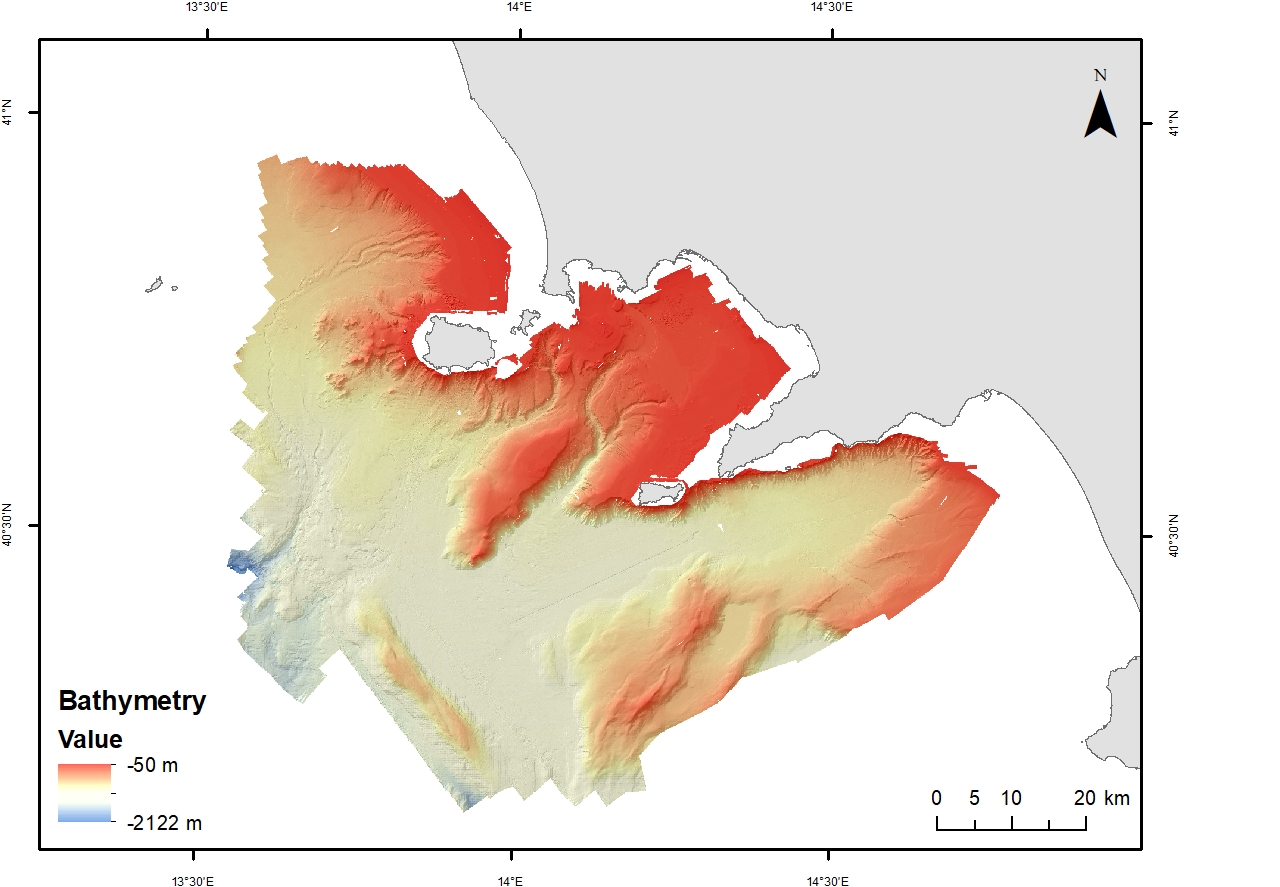
Bathymetry JG22_tot_20 m
Base
- Data (Creazione)
- 2023-07-01
- Data (Pubblicazione)
- 2024-02-15
- Identificatore
- http://libeccio.bo.ismar.cnr.it:8080/geonetwork/srv/eng/catalog.search#/metadata/90e848a3-3c24-4c65-8ffb-2723fc2a799e / GEONETWORK
- Identificatore
-
to be filled..
- Titolo alternativo
- EMODnet Bathymetry
- Data
- Crediti
-
© CNR-ISMAR,
Reference: F. Foglini, M. Rovere, R. Tonielli, G. Castellan, M. Prampolini, F. Budillon, M. Cuffaro, G. Di Martino, V. Grande, S. Innangi, M.F. Loreto, L. Langone, F. Madricardo, A. Mercorella, P. Montagna, C. Palmiotto, C. Pellegrini, A. Petrizzo, L. Petracchini, A. Remia, M. Sacchi, D. Sanchez Galvez, A.N. Tassetti, F. Trincardi. A new multi-resolution bathymetric dataset of the Gulf of Naples (Italy) from complementary multi-beam echosounders. (in press)
- Status
- In corso
- Frequenza di aggiornamento
- Secondo necessità
- GEMET - INSPIRE themes, version 1.0
-
- Elevation
- Geology
- Continents, countries, sea regions of the world.
-
- Mediterranean Sea
- Tyrrhenian Sea
- Italy
- Platform Type
-
- research vessel
- Survey type
-
- Geophysics
- Cartography
- Campaign
-
- JAMMEGAIA22
- Collection method
-
- Sonar system
- Device
-
- Multibeam
- Swath type
-
- Bathymetry
- Limitazione d’uso
- Do not use for navigation
- Vincoli di fruibilità
- Licenza
- Altri vincoli
- CC BY 4.0
- Vincoli di accesso
- Licenza
- Altri vincoli
- CC BY 4.0
- Classificazione
- Non riservato
- Tipo di rappresentazione spaziale
- Dati raster
- Lingua dei metadati
- English
- Set dei caratteri dei metadati
- UTF8
- Tema
-
- Quote e prodotti derivati
- Informazioni geoscientifiche
Estensione

Estensione
- Data di inizio
- 2022-09-28
- Data di fine
- 2022-10-18
- Informazioni supplementari
- none
- Identificatore del sistema di riferimento
- EPSG:32633 - WGS 84 / UTM zone 33N
- Livello di topologia
- Solo Geometria
- Oggetto di tipo geometrico
- Superficie
- Conteggio oggetto geometrico
- 1
- Formato di distribuzione
-
-
ESRI Shapefile
(
.shp
)
-
ESRI GRID
(
)
-
GeoTIFF
(
.tif
)
-
ASCII
(
.asc
)
-
ESRI Shapefile
(
.shp
)
- Risorsa online
-
Web application
(
WWW:LINK-1.0-http--link
)
ISMAR Spatial Database - Web application
- Risorsa online
-
Bathymetric surface
(
WWW:LINK-1.0-http--link
)
DTM (ascii, geotif, ESRI grid, shapefile)
- Livello
- Modello
- Dataset
- Bathymetric surface
Conformità
- Data (Pubblicazione)
- 2023-07-01
- Spiegazione
- Validated in Geonetwork according to the ISO19115 rules (25/25) and the INSPIRE rules (30/30)
- Pass
- Yes
- Genealogia del dato – Processo di produzione
-
Multibeam data was collected using EM2040 from 50 m to 150 m, EM712 from 150 m to 1000 m and EM304 from 1000 m to 1200 m. Water column and backscatter data was collected simultaneously. Seapath 380 was used for positing and MRU corrections. DGPS correction was sent over the EMSAT and IOSAT L band beams with a FURGO subscription of 1 month. EMSAT is 1545.9275 Mhz (1200 bits per second bitrate) and the IOSAT is 1545.8075 Mhz (1200 bps bitrate)
Sound velocity profiles were acquired twice a day with a Valeport swift SVP with a maximum depth of 500m and extended up to 1200 using the SIS sound velocity editor. SIS 5 was used to collect multi beam data for all MBs with the same installation parameters. For 2040 we changed the roll correction to 0.105°
Multi beam data was processed as soon after the acquisition on board the vessel with the software Qimera. The applied corrections to the bathymetric data include sound velocity correction, cut of external beams and manual removal of spikes. The processed Dynamic surface was exported as .xyz, .scii and .tiff format. The .kmall processed were exported to GSF and imported into FMGT software to run the backscatter mosaic at the same resolution of the DTM. The mosaic was exported as .xyz, .arcascii and .Geotiff. Navigation was exported for each MB line from Qimera as .txt file and converted to .shp file using global mapper.
- Identificatore del file di metadati
- 90e848a3-3c24-4c65-8ffb-2723fc2a799e XML
- Lingua dei metadati
- English
- Set dei caratteri dei metadati
- UTF8
- Identificatore metadati di rango superiore
- Survey JAMMEGAIA22 6cd1080c-f41f-4c9d-907b-297d25f554e5
- Livello gerarchico
- Modello
- Nome del livello gerarchico
- Bathymetric surface
- Data dei metadati
- 2024-06-04T13:13:21
- Nome dello Standard dei metadati
- ISO 19115:2003/19139
- Versione dello Standard dei metadati
- 1.0