 CNR-ISMAR
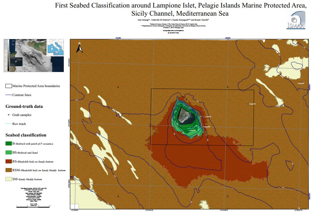
First Seabed Classification around Lampione Islet
First seabed map of the shallow-water areas of Lampione, the islet of the Pelagie Islands Marine Protected Area (Sicily Channel, Italy). The seafloor was mapped from the coast to a depth of about 75 m, using high-resolution multibeam systems (both for bathymetry and backscatter) along with ground-truth data in the form of grab samples and ROV videoobservations. By integrating these original data, a first seabed classification was produced through the use of the Remote Sensing Object Based Image Analysis, a semi-automatic segmentation approach. The resulting 1: 5.000 scale map includes sediment types and habitat distribution contributing to the knowledge of the peculiar marine ecosystem observed at Lampione. In particular, the map provides the first indication of the wide
occurrence of rhodolith/maërl habitats at Lampione, which are among the most important ecosystems in the Mediterranean Sea.
Base
- Data (Pubblicazione)
- 2019-02-20
- Identificatore
-
https://doi.org/10.1080/17445647.2019.1567401
- Data (Pubblicazione)
- 2019-02-20
- Altri dettagli
- How to cite this data: Innangi, S., Di Martino, G., Romagnoli, C., & Tonielli, R. (2019). Seabed classification around Lampione islet, Pelagie Islands Marine Protected area, Sicily Channel, Mediterranean Sea. Journal of Maps, 15(2), 153–164. https://doi.org/10.1080/17445647.2019.1567401
- Identificatore
-
http://libeccio.bo.ismar.cnr.it:8080/geonetwork/srv/eng/catalog.search#/metadata/64f9d38e-5196-46d8-9441-9da3882d3855
- Data (Pubblicazione)
- 2024-11-19
- Crediti
- © CNR-ISMAR
- Status
- Completato
- Frequenza di aggiornamento
- Secondo necessità
- Parole chiave
-
- seabed classification
- habitats
- lampione island
- pelagian islands
- nbfc
- GEMET - INSPIRE themes, version 1.0
-
- Habitats and biotopes
- Geology
- Limitazione d’uso
- ISMAR data policy: https://doi.org/10.26383/CNR-ISMAR.2023.6
- Vincoli di fruibilità
- Licenza
- Altri vincoli
- CC BY-NC-SA
- Vincoli di accesso
- Licenza
- Altri vincoli
- CC BY-NC-SA
- Classificazione
- Non riservato
- Tipo di rappresentazione spaziale
- Dati vettoriali
- Lingua dei metadati
- English
- Set dei caratteri dei metadati
- UTF8
- Tema
-
- Informazioni geoscientifiche
- Descrizione
- Italy
))
- Informazioni supplementari
- Lampione Island, Pelagian Islands, Strait of Sicily, Italy
- Identificatore del sistema di riferimento
- EPSG / 32633
informazioni sulla rappresentazione spaziale
- Livello di topologia
- Solo Geometria
- Oggetto di tipo geometrico
- Superficie
- Conteggio oggetto geometrico
- 7
- Formato di distribuzione
-
-
Shapefile
(
.shp
)
-
Shapefile
(
.shp
)
- Risorsa online
-
Scientific paper
(
DOI
)
Innangi et al., 2019
- Livello
- Dataset
- Dataset
- Dataset
Conformità
- Data (Pubblicazione)
- 2020-10-09
- Spiegazione
- Validated in Geonetwork according to the ISO19115 rules (25/25) and the INSPIRE rules (30/30)
- Pass
- Yes
- Genealogia del dato – Processo di produzione
-
Geophysical data were collected by the Institute for Coastal Marine Environment (IAMC, now ISMAR,
Institute of Marine Sciences) of the National Research Council (CNR) of Naples (Italy) during the oceanographic survey ‘BioGeoLin 2017’ (8–20 September 2017), onboard the R/V Minerva UNO (Di Martino
et al., 2017). During the survey, both seafloor superficial samples and direct observations were carried out by using, respectively, a Van Veen grab and a Pollux III R.O.V (Remotely Operated underwater Vehicle) equipped with high-resolution video camera, for ground-truth information. RSOBIA analyzing acoustic backscatter mosaic and bathymetric data characteristics (i.e. depth, roughness and slope) and, through the integration with other data such as ground-truth information, provided the semiautomated acoustic seabed classification of multibeam images.
- Identificatore del file di metadati
- 64f9d38e-5196-46d8-9441-9da3882d3855 XML
- Lingua dei metadati
- English
- Set dei caratteri dei metadati
- UTF8
- Livello gerarchico
- Dataset
- Data dei metadati
- 2024-11-25T16:56:49
- Nome dello Standard dei metadati
- ISO 19115:2003/19139
- Versione dello Standard dei metadati
- 1.0