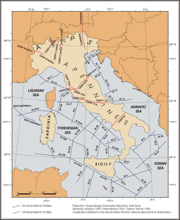
CROP Project - CROsta Profonda
The CROP (CROsta Profonda) Project, born in the 1990s from the collaboration between CNR-ENI and CNR-ENEL, represents a multidisciplinary research program aimed at understanding the geodynamic processes of the Italian territory, the definition and prevention of geological risk and research of energy resources through the study of geophysical data. The CROP database, generated by the acquisition, processing and interpretation (largely carried out by the OGS) of about 10,000 km of earth and sea reflection seismic profiles (about 1250 km on land and about 8700 km at sea ), is deposited at ISMAR-CNR.
Simple
- Date (Creation)
- 2021-05-14
- Identifier
- http://libeccio.bo.ismar.cnr.it:8080/geonetwork/srv/ita/catalog.search#/metadata/1d12b137-91e4-4f3b-af1d-a0748c581780 / GEONETWORK
- Unique resource identifier
- none
- Status
- On going
Principal investigator
National Research Council (CNR) - Institute of Marine Science (ISMAR)
-
Mariangela Ravaioli
(
Responsible for the CROP Database
)
Point of contact
National Research Council (CNR) - Institute of Marine Science (ISMAR)
-
Valentina Ferrante
(
Contact person for the CROP Database
)
- Maintenance and update frequency
- As needed
- GEMET - INSPIRE themes, version 1.0
-
- Geology
- Marine regions and subregions
-
- Adriatic Sea, Tyrrhenian Sea, Ionian Sea
- Project type
-
- European
- Project
-
- database
- sub-bottom profile
- Use limitation
- None
- Use constraints
- License
- Other constraints
- http://www.crop.cnr.it/it/bancadati/normativa-per-la-cessione-dei-dati
- Access constraints
- License
- Other constraints
- http://www.crop.cnr.it/it/bancadati/normativa-per-la-cessione-dei-dati
- Classification
- Restricted
- Metadata language
- English
- Character set
- UTF8
- Topic category
-
- Geoscientific information
- Description
- Italy
N
S
E
W
))
Extent
- Begin date
- 2012-01-01
- End date
- 2016-12-31
- Distribution format
-
-
PDF
(
.pdf
)
-
PDF
(
.pdf
)
Distributor
National Research Council (CNR) - Institute of Marine Science (ISMAR)
http://www.ismar.cnr.it/
- OnLine resource
-
Web page
(
WWW:LINK-1.0-http--link
)
Project web page
- Hierarchy level
- Non geographic dataset
- Other
- Project
Conformance result
- Date (Publication)
- 2020-10-09
- Explanation
- Validated in Geonetwork according to the ISO19115 rules (25/25) and the INSPIRE rules (30/30)
- Pass
- Yes
- Statement
- General explanation of the data producer_s knowledge about the lineage of a dataset
- File identifier
- 1d12b137-91e4-4f3b-af1d-a0748c581780 XML
- Metadata language
- English
- Character set
- UTF8
- Hierarchy level
- Non geographic dataset
- Hierarchy level name
- Project
- Date stamp
- 2022-07-25T16:58:16
- Metadata standard name
- ISO 19115:2003/19139
- Metadata standard version
- 1.0
Overviews

Spatial extent
N
S
E
W
))
Provided by

Associated resources
Not available
 CNR-ISMAR